Henley Beach night lights from space
Night Light of Henley Beach (South Australia) from space (Australia) Src. Average luminocity for 10x10km area is 53.1099% and for 50x50km: 26.6205%.
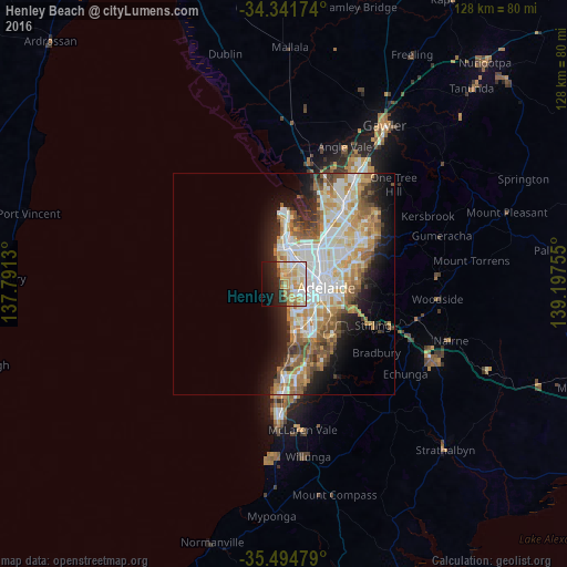
Analysis of Henley Beach night lights 2016
Square area 10x10 km:
 8.79%
8.79%90-99
11.72%80-89
10.81%70-79
14.84%60-69
6.41%50-59
1.83%40-49
2.2%30-39
2.01%20-29
13.19%10-19
16.3%0-9
11.9%Square area 50x50 km:
5.81%90-99
6.05%80-89
2.75%70-79
4.87%60-69
4.13%50-59
3.5%40-49
2.56%30-39
1.94%20-29
4.36%10-19
7.86%0-9
56.19%Clear (daylight) street map image can be seen on geolist.org.
Map coordinates:
34° 20' 30.3" South, 137° 47' 28.7" East
34° 55' 13" South, 138° 29' 39.9" East
35° 29' 41.2" South, 139° 11' 51.2" East
Some cities around Henley Beach sort by population:
• Seaton
3 km =1.9 mi,  41°
41°
• Findon
4.2 km =2.6 mi,  57°
57°
• Glenelg North
5.7 km =3.5 mi,  158°
158°
• Fulham Gardens
1.8 km =1.1 mi,  70°
70°
• Grange
2 km =1.2 mi,  349°
349°
• West Lakes
5.3 km =3.3 mi,  0°
0°
• Lockleys
3.1 km =1.9 mi,  101°
101°
• Glengowrie
8.4 km =5.2 mi,  152°
152°
9973091 (p: 5,840)
Sources (retrieved 2019-11-25):
» Earth at Night: Flat Maps 2012, 2016