Glenelg North night lights from space
Night Light of Glenelg North (South Australia) from space (Australia) Src. Average luminocity for 10x10km area is 59.7967% and for 50x50km: 25.2715%.
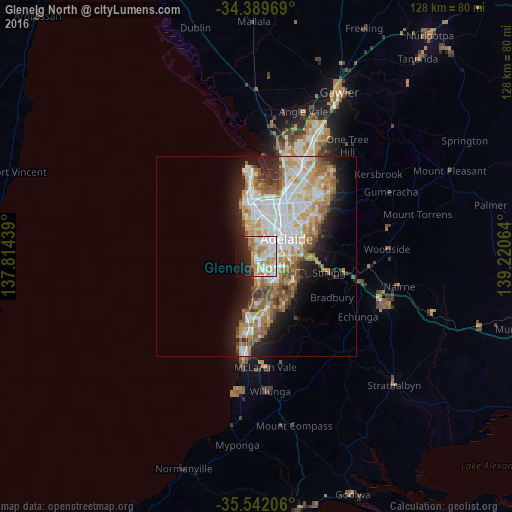
Analysis of Glenelg North night lights 2016
Square area 10x10 km:
 12.09%
90-99
17.03%80-89
6.96%70-79
14.65%60-69
10.44%50-59
1.1%40-49
1.47%30-39
2.01%20-29
14.1%10-19
15.38%0-9
4.76%Square area 50x50 km:
5.53%90-99
5.69%80-89
2.52%70-79
4.58%60-69
4%50-59
3.36%40-49
2.33%30-39
1.63%20-29
4.41%10-19
8.05%0-9
57.92%Clear (daylight) street map image can be seen on geolist.org.
Map coordinates:
34° 23' 22.9" South, 137° 48' 51.8" East
34° 58' 4.4" South, 138° 31' 3" East
35° 32' 31.4" South, 139° 13' 14.3" East
Some cities around Glenelg North sort by population:
• Seaton
7.6 km =4.7 mi,  359°
359°
• Fulham Gardens
5.9 km =3.7 mi, 356°
• Henley Beach
5.7 km =3.5 mi,  338°
338°
• Lockleys
4.8 km =3 mi,  11°
11°
• Mitchell Park
6.3 km =3.9 mi,  138°
138°
• Somerton Park
3.3 km =2.1 mi,  173°
173°
• Glengowrie
2.8 km =1.7 mi, 140°
• Warradale
3.5 km =2.2 mi,  158°
158°
9973115 (p: 6,166)
Sources (retrieved 2019-11-25):
» Earth at Night: Flat Maps 2012, 2016