Frankston South night lights from space
Night Light of Frankston South (Victoria) from space (Australia) Src. Average luminocity for 10x10km area is 43.9303% and for 50x50km: 20.6683%.
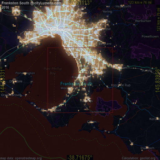
Analysis of Frankston South night lights 2016
Square area 10x10 km:
 4.25%
4.25%90-99
4.42%80-89
3.23%70-79
7.14%60-69
7.14%50-59
12.24%40-49
10.71%30-39
11.05%20-29
17.86%10-19
21.26%0-9
0.68%Square area 50x50 km:
2.8%90-99
3.45%80-89
1.7%70-79
3.89%60-69
3.89%50-59
3.75%40-49
3.04%30-39
3.06%20-29
4.44%10-19
9.47%0-9
60.5%Clear (daylight) street map image can be seen on geolist.org.
Map coordinates:
37° 36' 40.1" South, 144° 25' 59.9" East
38° 9' 57.7" South, 145° 8' 11.1" East
38° 43' 0.3" South, 145° 50' 22.4" East
Some cities around Frankston South sort by population:
• Mornington
10.3 km =6.4 mi,  235°
235°
• Langwarrin
2.6 km =1.6 mi,  91°
91°
• Carrum Downs
8 km =5 mi,  23°
23°
• Mount Eliza
5 km =3.1 mi,  247°
247°
• Seaford
7.3 km =4.5 mi,  357°
357°
• Somerville
6.2 km =3.9 mi,  154°
154°
• Skye
9.7 km =6 mi,  45°
45°
• Patterson Lakes
10.8 km =6.7 mi,  3°
3°
9972527 (p: 17,826)
Sources (retrieved 2019-11-25):
» Earth at Night: Flat Maps 2012, 2016