Elwood night lights from space
Night Light of Elwood (Victoria) from space (Australia) Src. Average luminocity for 10x10km area is 70.9432% and for 50x50km: 53.9063%.
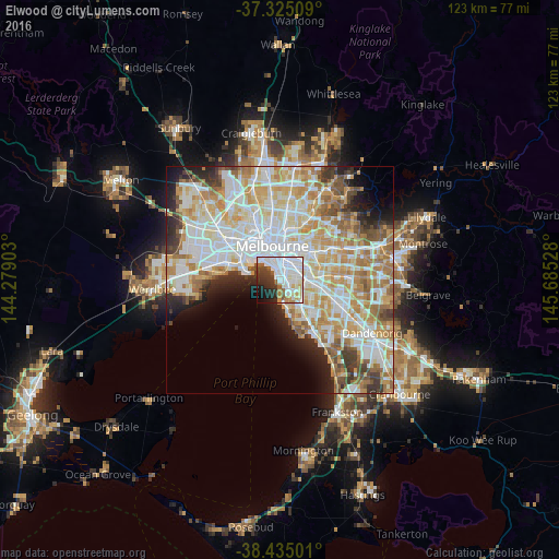
Analysis of Elwood night lights 2016
Square area 10x10 km:
 33.28%
90-99
18.18%80-89
3.57%70-79
5.68%60-69
2.27%50-59
5.36%40-49
3.73%30-39
8.93%20-29
9.74%10-19
6.98%0-9
2.27%Square area 50x50 km:
15.36%90-99
13.88%80-89
7.07%70-79
9.09%60-69
7.55%50-59
4.62%40-49
3.48%30-39
3.57%20-29
4.53%10-19
5.53%0-9
25.32%Clear (daylight) street map image can be seen on geolist.org.
Map coordinates:
37° 19' 30.3" South, 144° 16' 44.5" East
37° 52' 55.7" South, 144° 58' 55.7" East
38° 26' 6" South, 145° 41' 7" East
Some cities around Elwood sort by population:
• Brighton
3.2 km =2 mi,  145°
145°
• Saint Kilda
1.6 km =1 mi,  356°
356°
• St Kilda East
2.4 km =1.5 mi,  41°
41°
• Prahran
3.6 km =2.2 mi,  15°
15°
• Elsternwick
1.8 km =1.1 mi,  104°
104°
• Windsor
3.3 km =2.1 mi, 15°
• Caulfield
3.6 km =2.2 mi,  90°
90°
• Balaclava
2.3 km =1.4 mi, 42°
7932620 (p: 15,122)
Sources (retrieved 2019-11-25):
» Earth at Night: Flat Maps 2012, 2016