Windsor night lights from space
Night Light of Windsor (Victoria) from space (Australia) Src. Average luminocity for 10x10km area is 88.3831% and for 50x50km: 55.6413%.
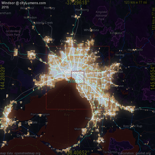
Analysis of Windsor night lights 2016
Square area 10x10 km:
 56.17%
90-99
22.89%80-89
2.92%70-79
1.14%60-69
0.49%50-59
2.92%40-49
3.08%30-39
6.49%20-29
3.57%10-19
0.32%0-9
0%Square area 50x50 km:
15.71%90-99
14.26%80-89
7.22%70-79
9.31%60-69
8.09%50-59
5.01%40-49
3.55%30-39
3.37%20-29
4.76%10-19
6.28%0-9
22.43%Clear (daylight) street map image can be seen on geolist.org.
Map coordinates:
37° 17' 46.2" South, 144° 17' 21.4" East
37° 51' 12.4" South, 144° 59' 32.7" East
38° 24' 23.5" South, 145° 41' 43.9" East
Some cities around Windsor sort by population:
• South Yarra
1.7 km =1.1 mi,  357°
357°
• Saint Kilda
1.9 km =1.2 mi,  212°
212°
• St Kilda East
1.5 km =0.9 mi,  153°
153°
• Prahran
0.3 km =0.2 mi,  14°
14°
• Toorak
2.3 km =1.4 mi,  55°
55°
• South Melbourne
3.2 km =2 mi,  314°
314°
• Armadale
2.5 km =1.6 mi,  95°
95°
• Balaclava
1.6 km =1 mi,  155°
155°
2143407 (p: 7,257)
Sources (retrieved 2019-11-25):
» Earth at Night: Flat Maps 2012, 2016