Saint Kilda night lights from space
Night Light of Saint Kilda (Victoria) from space (Australia) Src. Average luminocity for 10x10km area is 77.8166% and for 50x50km: 54.5893%.
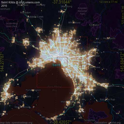

Analysis of Saint Kilda night lights 2016
Square area 10x10 km:
 43.99%
90-99
18.51%80-89
3.41%70-79
3.25%60-69
0.81%50-59
4.87%40-49
3.57%30-39
8.77%20-29
7.95%10-19
4.55%0-9
0.32%Square area 50x50 km:
15.56%90-99
14.06%80-89
7.12%70-79
9.12%60-69
7.75%50-59
4.62%40-49
3.45%30-39
3.57%20-29
4.69%10-19
6.03%0-9
24.02%Clear (daylight) street map image can be seen on geolist.org.
Map coordinates:
37° 18' 37.6" South, 144° 16' 40.3" East
37° 52' 3.4" South, 144° 58' 51.6" East
38° 25' 14.1" South, 145° 41' 2.8" East
Some cities around Saint Kilda sort by population:
• South Yarra
3.4 km =2.1 mi,  15°
15°
• Elwood
1.6 km =1 mi,  176°
176°
• St Kilda East
1.7 km =1.1 mi,  83°
83°
• Prahran
2.1 km =1.3 mi,  30°
30°
• Elsternwick
2.8 km =1.7 mi,  137°
137°
• Armadale
3.7 km =2.3 mi,  68°
68°
• Windsor
1.9 km =1.2 mi, 32°
• Balaclava
1.7 km =1.1 mi,  86°
86°
2150660 (p: 20,417)
Sources (retrieved 2019-11-25):
» Earth at Night: Flat Maps 2012, 2016