St Kilda East night lights from space
Night Light of St Kilda East (Victoria) from space (Australia) Src. Average luminocity for 10x10km area is 86.1575% and for 50x50km: 55.462%.
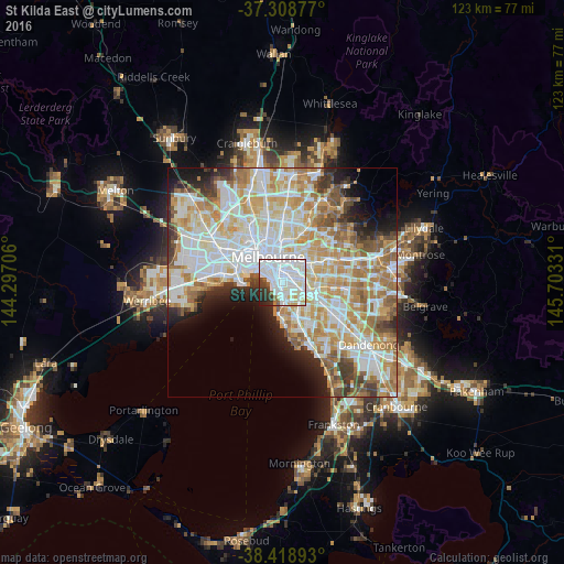
Analysis of St Kilda East night lights 2016
Square area 10x10 km:
 48.86%
90-99
24.51%80-89
4.71%70-79
3.25%60-69
0.81%50-59
3.25%40-49
2.44%30-39
6.33%20-29
4.87%10-19
0.97%0-9
0%Square area 50x50 km:
15.73%90-99
14.2%80-89
7.16%70-79
9.25%60-69
8.23%50-59
5.1%40-49
3.62%30-39
3.32%20-29
4.33%10-19
5.85%0-9
23.22%Clear (daylight) street map image can be seen on geolist.org.
Map coordinates:
37° 18' 31.6" South, 144° 17' 49.4" East
37° 51' 57.4" South, 145° 0' 0.6" East
38° 25' 8.1" South, 145° 42' 11.9" East
Some cities around St Kilda East sort by population:
• Saint Kilda
1.7 km =1.1 mi,  263°
263°
• Elwood
2.4 km =1.5 mi,  221°
221°
• Caulfield North
2.3 km =1.4 mi,  112°
112°
• Prahran
1.8 km =1.1 mi,  339°
339°
• Elsternwick
2.3 km =1.4 mi,  174°
174°
• Armadale
2.1 km =1.3 mi,  56°
56°
• Windsor
1.5 km =0.9 mi,  333°
333°
• Balaclava
0.1 km =0.1 mi,  191°
191°
7303250 (p: 12,983)
Sources (retrieved 2019-11-25):
» Earth at Night: Flat Maps 2012, 2016