East Albury night lights from space
Night Light of East Albury (New South Wales) from space (Australia) Src. Average luminocity for 10x10km area is 46.8663% and for 50x50km: 4.0893%.
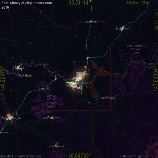
Analysis of East Albury night lights 2016
Square area 10x10 km:
 7.14%
7.14%90-99
7.33%80-89
5.49%70-79
7.69%60-69
9.52%50-59
8.06%40-49
4.58%30-39
2.75%20-29
22.71%10-19
21.61%0-9
3.11%Square area 50x50 km:
0.37%90-99
0.43%80-89
0.28%70-79
0.72%60-69
1%50-59
0.82%40-49
0.29%30-39
0.45%20-29
1.36%10-19
3.5%0-9
90.78%Clear (daylight) street map image can be seen on geolist.org.
Map coordinates:
35° 30' 40.1" South, 146° 13' 36.4" East
36° 4' 53.2" South, 146° 55' 47.7" East
36° 38' 51.5" South, 147° 37' 58.9" East
Some cities around East Albury sort by population:
• Wodonga
5.9 km =3.7 mi,  219°
219°
• Wangaratta
62.7 km =39 mi,  240°
240°
• West Wodonga
8.4 km =5.2 mi, 236°
• Lavington
4.7 km =2.9 mi,  10°
10°
• Thurgoona
7.8 km =4.8 mi,  49°
49°
• North Albury
2.7 km =1.7 mi,  0°
0°
• Albury
0.9 km =0.6 mi,  324°
324°
• Corowa
49.8 km =30.9 mi,  280°
280°
10116056 (p: 5,942)
Sources (retrieved 2019-11-25):
» Earth at Night: Flat Maps 2012, 2016