Westmeadows night lights from space
Night Light of Westmeadows (Victoria) from space (Australia) Src. Average luminocity for 10x10km area is 74.9643% and for 50x50km: 44.7774%.
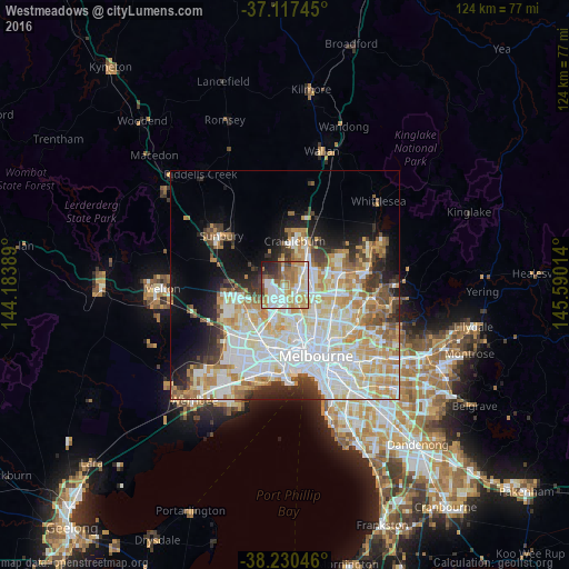
Analysis of Westmeadows night lights 2016
Square area 10x10 km:
 19.9%
19.9%90-99
18.2%80-89
9.52%70-79
16.5%60-69
12.24%50-59
5.61%40-49
7.48%30-39
2.89%20-29
5.78%10-19
1.87%0-9
0%Square area 50x50 km:
12.75%90-99
11.19%80-89
5.72%70-79
7.14%60-69
5.43%50-59
3.67%40-49
3.2%30-39
3.26%20-29
4.94%10-19
7.62%0-9
35.07%Clear (daylight) street map image can be seen on geolist.org.
Map coordinates:
37° 7' 2.8" South, 144° 11' 2" East
37° 40' 33.7" South, 144° 53' 13.2" East
38° 13' 49.7" South, 145° 35' 24.5" East
Some cities around Westmeadows sort by population:
• Glenroy
4.9 km =3 mi,  123°
123°
• Greenvale
5.1 km =3.2 mi,  339°
339°
• Meadow Heights
3.9 km =2.4 mi,  45°
45°
• Broadmeadows
2.8 km =1.7 mi,  99°
99°
• Gladstone Park
1.3 km =0.8 mi,  181°
181°
• Airport West
5.4 km =3.4 mi,  185°
185°
• Dallas
4.3 km =2.7 mi,  82°
82°
• Tullamarine
2.9 km =1.8 mi, 190°
9972415 (p: 5,780)
Sources (retrieved 2019-11-25):
» Earth at Night: Flat Maps 2012, 2016