Hadfield night lights from space
Night Light of Hadfield (Victoria) from space (Australia) Src. Average luminocity for 10x10km area is 88.4643% and for 50x50km: 50.0584%.
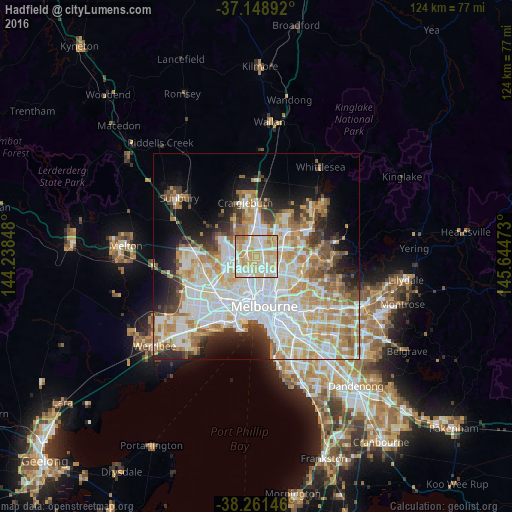
Analysis of Hadfield night lights 2016
Square area 10x10 km:
 24.83%
90-99
23.98%80-89
26.19%70-79
20.75%60-69
4.25%50-59
0%40-49
0%30-39
0%20-29
0%10-19
0%0-9
0%Square area 50x50 km:
13.94%90-99
12.37%80-89
6.37%70-79
8.23%60-69
6.65%50-59
4.21%40-49
3.52%30-39
3.5%20-29
5.86%10-19
8.33%0-9
27.01%Clear (daylight) street map image can be seen on geolist.org.
Map coordinates:
37° 8' 56.1" South, 144° 14' 18.5" East
37° 42' 26.2" South, 144° 56' 29.8" East
38° 15' 41.3" South, 145° 38' 41" East
Some cities around Hadfield sort by population:
• Glenroy
1.1 km =0.7 mi,  318°
318°
• Pascoe Vale
3 km =1.9 mi,  194°
194°
• Fawkner
2.4 km =1.5 mi,  115°
115°
• Broadmeadows
3.6 km =2.2 mi,  326°
326°
• Pascoe Vale South
3.6 km =2.2 mi,  173°
173°
• Strathmore
3.7 km =2.3 mi,  210°
210°
• Coburg North
2.9 km =1.8 mi,  143°
143°
• Oak Park
2.3 km =1.4 mi,  237°
237°
9972464 (p: 5,589)
Sources (retrieved 2019-11-25):
» Earth at Night: Flat Maps 2012, 2016