Broadmeadows night lights from space
Night Light of Broadmeadows (Victoria) from space (Australia) Src. Average luminocity for 10x10km area is 83.0986% and for 50x50km: 46.3418%.
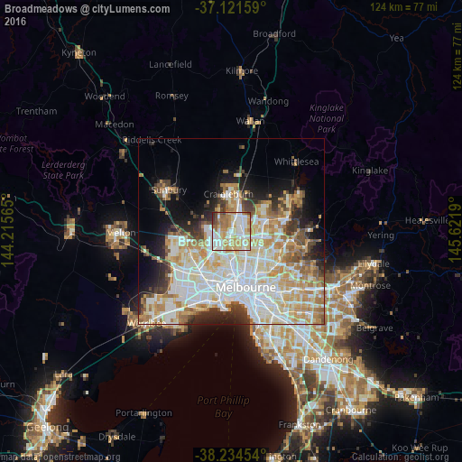
Analysis of Broadmeadows night lights 2016
Square area 10x10 km:
 25%
25%90-99
20.24%80-89
16.33%70-79
16.67%60-69
11.73%50-59
4.25%40-49
3.4%30-39
1.36%20-29
1.02%10-19
0%0-9
0%Square area 50x50 km:
13.09%90-99
11.39%80-89
5.96%70-79
7.41%60-69
6.07%50-59
3.91%40-49
3.34%30-39
3.33%20-29
5.21%10-19
7.48%0-9
32.82%Clear (daylight) street map image can be seen on geolist.org.
Map coordinates:
37° 7' 17.7" South, 144° 12' 56.3" East
37° 40' 48.5" South, 144° 55' 7.6" East
38° 14' 4.3" South, 145° 37' 18.8" East
Some cities around Broadmeadows sort by population:
• Glenroy
2.6 km =1.6 mi,  149°
149°
• Meadow Heights
3.2 km =2 mi,  359°
359°
• Gladstone Park
2.9 km =1.8 mi,  253°
253°
• Dallas
1.8 km =1.1 mi,  54°
54°
• Tullamarine
4.1 km =2.5 mi,  234°
234°
• Westmeadows
2.8 km =1.7 mi,  279°
279°
• Hadfield
3.6 km =2.2 mi, 146°
• Campbellfield
4 km =2.5 mi,  63°
63°
2173964 (p: 12,009)
Sources (retrieved 2019-11-25):
» Earth at Night: Flat Maps 2012, 2016