Gladstone Park night lights from space
Night Light of Gladstone Park (Victoria) from space (Australia) Src. Average luminocity for 10x10km area is 79.8827% and for 50x50km: 46.4384%.
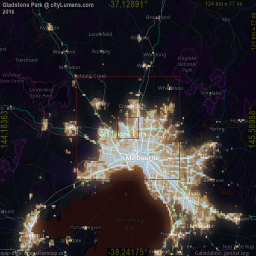
Analysis of Gladstone Park night lights 2016
Square area 10x10 km:
 21.77%
90-99
21.09%80-89
11.73%70-79
17.69%60-69
11.9%50-59
4.76%40-49
5.78%30-39
2.38%20-29
2.89%10-19
0%0-9
0%Square area 50x50 km:
13.19%90-99
11.59%80-89
6.02%70-79
7.43%60-69
5.57%50-59
3.84%40-49
3.26%30-39
3.35%20-29
5.18%10-19
8.21%0-9
32.37%Clear (daylight) street map image can be seen on geolist.org.
Map coordinates:
37° 7' 44.1" South, 144° 11' 1.1" East
37° 41' 14.7" South, 144° 53' 12.3" East
38° 14' 30.3" South, 145° 35' 23.6" East
Some cities around Gladstone Park sort by population:
• Glenroy
4.3 km =2.7 mi,  108°
108°
• Meadow Heights
4.9 km =3 mi,  34°
34°
• Broadmeadows
2.9 km =1.8 mi,  73°
73°
• Airport West
4.2 km =2.6 mi,  186°
186°
• Dallas
4.7 km =2.9 mi, 66°
• Tullamarine
1.6 km =1 mi,  198°
198°
• Oak Park
4.5 km =2.8 mi,  140°
140°
• Westmeadows
1.3 km =0.8 mi,  1°
1°
6290241 (p: 8,260)
Sources (retrieved 2019-11-25):
» Earth at Night: Flat Maps 2012, 2016