Underwood night lights from space
Night Light of Underwood (Queensland) from space (Australia) Src. Average luminocity for 10x10km area is 74.2262% and for 50x50km: 40.9532%.
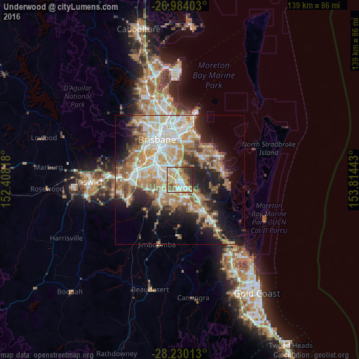
Analysis of Underwood night lights 2016
Square area 10x10 km:
 14.88%
90-99
16.67%80-89
15.28%70-79
15.67%60-69
14.88%50-59
6.15%40-49
4.56%30-39
6.15%20-29
5.75%10-19
0%0-9
0%Square area 50x50 km:
7.76%90-99
8.59%80-89
5.06%70-79
5.68%60-69
11%50-59
3.52%40-49
3.78%30-39
4.21%20-29
6.91%10-19
12.34%0-9
31.15%Clear (daylight) street map image can be seen on geolist.org.
Map coordinates:
26° 59' 2.5" South, 152° 24' 29.4" East
27° 36' 31.9" South, 153° 6' 40.7" East
28° 13' 48.5" South, 153° 48' 51.9" East
Some cities around Underwood sort by population:
• Logan City
3.4 km =2.1 mi,  183°
183°
• Eight Mile Plains
3 km =1.9 mi,  338°
338°
• Rochedale South
1.9 km =1.2 mi,  37°
37°
• Runcorn
3.6 km =2.2 mi,  290°
290°
• Woodridge
2.9 km =1.8 mi,  202°
202°
• Springwood
1.8 km =1.1 mi,  100°
100°
• Kuraby
1.8 km =1.1 mi,  277°
277°
• Logan Central
3.9 km =2.4 mi,  185°
185°
8347902 (p: 6,285)
Sources (retrieved 2019-11-25):
» Earth at Night: Flat Maps 2012, 2016