Blakeview night lights from space
Night Light of Blakeview (South Australia) from space (Australia) Src. Average luminocity for 10x10km area is 40.9808% and for 50x50km: 18.4406%.
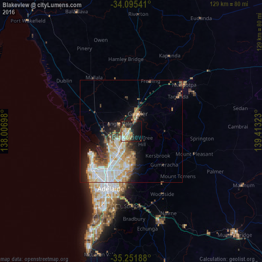
Analysis of Blakeview night lights 2016
Square area 10x10 km:
 5.42%
5.42%90-99
8.57%80-89
4.9%70-79
9.09%60-69
5.59%50-59
4.72%40-49
2.27%30-39
3.15%20-29
12.41%10-19
29.55%0-9
14.34%Square area 50x50 km:
3.79%90-99
4.4%80-89
2.03%70-79
3.17%60-69
2.48%50-59
2.17%40-49
1.56%30-39
1.94%20-29
3.03%10-19
6.4%0-9
69.02%Clear (daylight) street map image can be seen on geolist.org.
Map coordinates:
34° 5' 43.5" South, 138° 0' 25.1" East
34° 40' 32.4" South, 138° 42' 36.4" East
35° 15' 6.8" South, 139° 24' 47.6" East
Some cities around Blakeview sort by population:
• Gawler
8.9 km =5.5 mi,  23°
23°
• Craigmore
2.8 km =1.7 mi,  181°
181°
• Greenwith
10 km =6.2 mi, 178°
• Andrews Farm
4.4 km =2.7 mi,  269°
269°
• Davoren Park
4.1 km =2.5 mi,  246°
246°
• Munno Para West
3 km =1.9 mi,  294°
294°
• Gawler East
9.8 km =6.1 mi,  29°
29°
• Elizabeth Downs
3.2 km =2 mi,  212°
212°
8348445 (p: 7,043)
Sources (retrieved 2019-11-25):
» Earth at Night: Flat Maps 2012, 2016