Corlette night lights from space
Night Light of Corlette (New South Wales) from space (Australia) Src. Average luminocity for 10x10km area is 10.1888% and for 50x50km: 1.3528%.
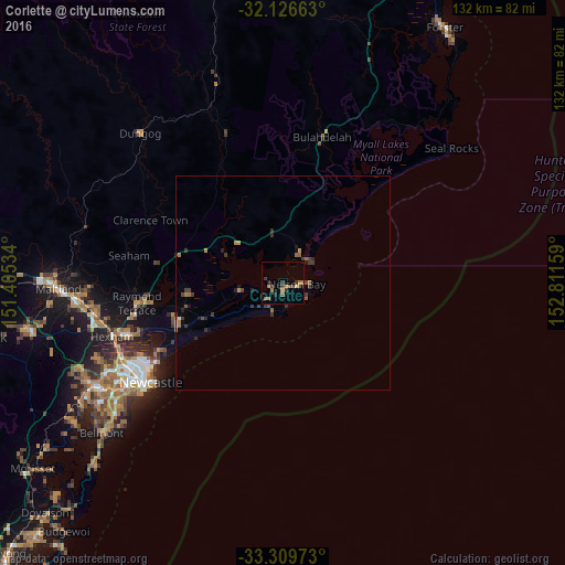
Analysis of Corlette night lights 2016
Square area 10x10 km:
 0%
0%90-99
0%80-89
1.4%70-79
1.75%60-69
2.8%50-59
2.45%40-49
1.92%30-39
2.97%20-29
0.7%10-19
1.4%0-9
84.62%Square area 50x50 km:
0.03%90-99
0.03%80-89
0.06%70-79
0.19%60-69
0.33%50-59
0.3%40-49
0.22%30-39
0.69%20-29
0.26%10-19
0.28%0-9
97.61%Clear (daylight) street map image can be seen on geolist.org.
Map coordinates:
32° 7' 35.9" South, 151° 24' 19.2" East
32° 43' 12.5" South, 152° 6' 30.5" East
33° 18' 35" South, 152° 48' 41.7" East
Some cities around Corlette sort by population:
• Newcastle
38.5 km =23.9 mi,  232°
232°
• Raymond Terrace
33.8 km =21 mi,  262°
262°
• Merewether
42.5 km =26.4 mi, 233°
• New Lambton
44 km =27.3 mi,  238°
238°
• Medowie
22.7 km =14.1 mi, 263°
• Mayfield
40 km =24.9 mi, 240°
• Nelson Bay
3.3 km =2.1 mi,  90°
90°
• Adamstown
43.2 km =26.8 mi, 235°
6690772 (p: 5,147)
Sources (retrieved 2019-11-25):
» Earth at Night: Flat Maps 2012, 2016