Caringbah night lights from space
Night Light of Caringbah (New South Wales) from space (Australia) Src. Average luminocity for 10x10km area is 51.2483% and for 50x50km: 33.2987%.
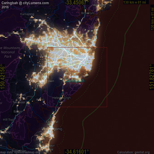
Analysis of Caringbah night lights 2016
Square area 10x10 km:
 7.52%
7.52%90-99
6.47%80-89
3.32%70-79
5.24%60-69
18.36%50-59
11.19%40-49
4.55%30-39
17.48%20-29
9.79%10-19
15.03%0-9
1.05%Square area 50x50 km:
9.53%90-99
9.5%80-89
4.47%70-79
4.41%60-69
3.92%50-59
2.54%40-49
1.72%30-39
2.45%20-29
3.29%10-19
5.33%0-9
52.84%Clear (daylight) street map image can be seen on geolist.org.
Map coordinates:
33° 27' 2.4" South, 150° 25' 17.6" East
34° 2' 7.2" South, 151° 7' 28.8" East
34° 36' 57.6" South, 151° 49' 40.1" East
Some cities around Caringbah sort by population:
• Cronulla
3.8 km =2.4 mi,  142°
142°
• Miranda
2.3 km =1.4 mi,  261°
261°
• Sylvania
3.6 km =2.2 mi,  315°
315°
• Sans Souci
5.1 km =3.2 mi,  8°
8°
• Kirrawee
5.1 km =3.2 mi,  266°
266°
• Gymea
3.6 km =2.2 mi, 268°
• Gymea Bay
3.9 km =2.4 mi,  241°
241°
• Blakehurst
5.1 km =3.2 mi,  343°
343°
2172311 (p: 11,830)
Sources (retrieved 2019-11-25):
» Earth at Night: Flat Maps 2012, 2016