Bull Creek night lights from space
Night Light of Bull Creek (Western Australia) from space (Australia) Src. Average luminocity for 10x10km area is 85.2273% and for 50x50km: 40.9729%.
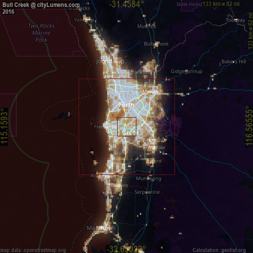
Analysis of Bull Creek night lights 2016
Square area 10x10 km:
 18.71%
90-99
25.17%80-89
19.41%70-79
27.45%60-69
5.77%50-59
2.27%40-49
1.22%30-39
0%20-29
0%10-19
0%0-9
0%Square area 50x50 km:
9.29%90-99
9.9%80-89
4.48%70-79
5.86%60-69
8.07%50-59
4.88%40-49
3.54%30-39
3.36%20-29
6.24%10-19
8.41%0-9
35.97%Clear (daylight) street map image can be seen on geolist.org.
Map coordinates:
31° 27' 30.2" South, 115° 9' 33.5" East
32° 3' 22.5" South, 115° 51' 44.7" East
32° 39' 0.8" South, 116° 33' 56" East
Some cities around Bull Creek sort by population:
• Willetton
2.4 km =1.5 mi,  80°
80°
• Leeming
2.1 km =1.3 mi,  170°
170°
• Kardinya
4.6 km =2.9 mi,  256°
256°
• Applecross
5.2 km =3.2 mi,  328°
328°
• Mount Pleasant
2.2 km =1.4 mi, 327°
• Winthrop
3.1 km =1.9 mi,  278°
278°
• Riverton
4.2 km =2.6 mi,  54°
54°
• Booragoon
3.3 km =2.1 mi,  304°
304°
8349218 (p: 7,624)
Sources (retrieved 2019-11-25):
» Earth at Night: Flat Maps 2012, 2016