Broadbeach Waters night lights from space
Night Light of Broadbeach Waters (Queensland) from space (Australia) Src. Average luminocity for 10x10km area is 65.5795% and for 50x50km: 16.0405%.
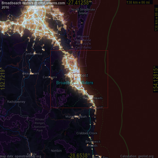
Analysis of Broadbeach Waters night lights 2016
Square area 10x10 km:
 18.37%
90-99
18.56%80-89
8.33%70-79
5.87%60-69
11.93%50-59
2.46%40-49
2.08%30-39
6.06%20-29
15.91%10-19
10.42%0-9
0%Square area 50x50 km:
2.8%90-99
2.97%80-89
1.52%70-79
1.28%60-69
4.49%50-59
1.68%40-49
1.86%30-39
1.89%20-29
3.95%10-19
9.26%0-9
68.31%Clear (daylight) street map image can be seen on geolist.org.
Map coordinates:
27° 24' 45.3" South, 152° 43' 18.8" East
28° 2' 5.9" South, 153° 25' 30.1" East
28° 39' 13.7" South, 154° 7' 41.3" East
Some cities around Broadbeach Waters sort by population:
• Gold Coast
3.9 km =2.4 mi,  8°
8°
• Surfers Paradise
3.6 km =2.2 mi, 7°
• Robina
5 km =3.1 mi,  218°
218°
• Mermaid Waters
1.7 km =1.1 mi,  160°
160°
• Benowa
4.9 km =3 mi,  308°
308°
• Mermaid Beach
1.4 km =0.9 mi,  136°
136°
• Miami
4.4 km =2.7 mi, 158°
• Merrimac
5.4 km =3.4 mi,  250°
250°
10063038 (p: 7,833)
Sources (retrieved 2019-11-25):
» Earth at Night: Flat Maps 2012, 2016