Botany night lights from space
Night Light of Botany (New South Wales) from space (Australia) Src. Average luminocity for 10x10km area is 86.6906% and for 50x50km: 38.4247%.
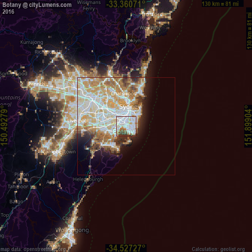
Analysis of Botany night lights 2016
Square area 10x10 km:
 41.08%
90-99
29.72%80-89
3.85%70-79
5.59%60-69
4.02%50-59
5.07%40-49
4.02%30-39
6.47%20-29
0.17%10-19
0%0-9
0%Square area 50x50 km:
9.98%90-99
10.66%80-89
5.24%70-79
5.96%60-69
6.15%50-59
2.98%40-49
2.06%30-39
2.55%20-29
3.11%10-19
5.23%0-9
46.1%Clear (daylight) street map image can be seen on geolist.org.
Map coordinates:
33° 21' 38.6" South, 150° 29' 34" East
33° 56' 45.6" South, 151° 11' 45.3" East
34° 31' 38.2" South, 151° 53' 56.5" East
Some cities around Botany sort by population:
• Maroubra
3.5 km =2.2 mi,  97°
97°
• Mascot
2.2 km =1.4 mi,  354°
354°
• Kingsford
3.8 km =2.4 mi,  49°
49°
• Kensington
3.8 km =2.4 mi,  40°
40°
• Matraville
3.8 km =2.4 mi,  120°
120°
• Eastlakes
2.2 km =1.4 mi, 43°
• Wolli Creek
4.3 km =2.7 mi,  292°
292°
• Hillsdale
3 km =1.9 mi, 101°
2174563 (p: 10,732)
Sources (retrieved 2019-11-25):
» Earth at Night: Flat Maps 2012, 2016