Bongaree night lights from space
Night Light of Bongaree (Queensland) from space (Australia) Src. Average luminocity for 10x10km area is 17.8807% and for 50x50km: 10.5533%.
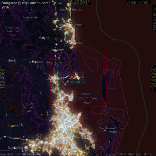
Analysis of Bongaree night lights 2016
Square area 10x10 km:
 0.19%
0.19%90-99
2.08%80-89
0.76%70-79
1.52%60-69
6.63%50-59
5.3%40-49
3.6%30-39
2.65%20-29
1.14%10-19
6.82%0-9
69.32%Square area 50x50 km:
1.03%90-99
1.21%80-89
0.82%70-79
0.54%60-69
4.34%50-59
1.53%40-49
1.67%30-39
2.21%20-29
2.73%10-19
5.86%0-9
78.06%Clear (daylight) street map image can be seen on geolist.org.
Map coordinates:
26° 27' 21.3" South, 152° 27' 22.7" East
27° 5' 1.2" South, 153° 9' 33.9" East
27° 42' 28.5" South, 153° 51' 45.2" East
Some cities around Bongaree sort by population:
• Deception Bay
18 km =11.2 mi,  227°
227°
• Kippa-Ring
17.5 km =10.9 mi,  205°
205°
• Scarborough
14 km =8.7 mi,  200°
200°
• Clontarf
20.5 km =12.7 mi, 203°
• Margate
19.2 km =11.9 mi, 198°
• Rothwell
18.3 km =11.4 mi,  217°
217°
• Burpengary East
17.2 km =10.7 mi,  246°
246°
• Banksia Beach
5.1 km =3.2 mi,  342°
342°
2174933 (p: 7,010)
Sources (retrieved 2019-11-25):
» Earth at Night: Flat Maps 2012, 2016