Beaudesert night lights from space
Night Light of Beaudesert (Queensland) from space (Australia) Src. Average luminocity for 10x10km area is 5.1591% and for 50x50km: 1.4373%.
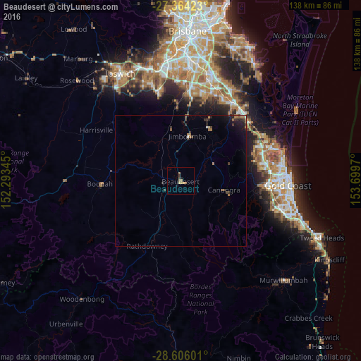
Analysis of Beaudesert night lights 2016
Square area 10x10 km:
 0%
0%90-99
0%80-89
0.76%70-79
0%60-69
4.55%50-59
0%40-49
0.76%30-39
0.76%20-29
0.38%10-19
1.14%0-9
91.67%Square area 50x50 km:
0.08%90-99
0.03%80-89
0.06%70-79
0.02%60-69
0.66%50-59
0.14%40-49
0.22%30-39
0.46%20-29
0.31%10-19
1.05%0-9
96.98%Clear (daylight) street map image can be seen on geolist.org.
Map coordinates:
27° 21' 51.2" South, 152° 17' 36.4" East
27° 59' 12.9" South, 152° 59' 47.7" East
28° 36' 21.6" South, 153° 41' 58.9" East
Some cities around Beaudesert sort by population:
• Upper Coomera
30.9 km =19.2 mi,  66°
66°
• Pacific Pines
31.6 km =19.6 mi,  80°
80°
• Jimboomba
17.6 km =10.9 mi,  9°
9°
• Oxenford
32.9 km =20.4 mi, 70°
• Tamborine Mountain
20 km =12.4 mi, 84°
• Greenbank
30.1 km =18.7 mi,  357°
357°
• Highland Park
33.2 km =20.6 mi,  95°
95°
• Maudsland
26.8 km =16.7 mi, 81°
2176495 (p: 6,364)
Sources (retrieved 2019-11-25):
» Earth at Night: Flat Maps 2012, 2016