Banyo night lights from space
Night Light of Banyo (Queensland) from space (Australia) Src. Average luminocity for 10x10km area is 84.1932% and for 50x50km: 38.5271%.
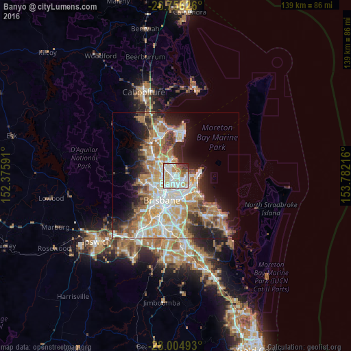
Analysis of Banyo night lights 2016
Square area 10x10 km:
 28.79%
90-99
28.6%80-89
13.45%70-79
7.77%60-69
8.33%50-59
2.84%40-49
2.46%30-39
3.98%20-29
3.6%10-19
0.19%0-9
0%Square area 50x50 km:
7.83%90-99
8.58%80-89
5.05%70-79
5.28%60-69
9.44%50-59
2.88%40-49
3.78%30-39
4.03%20-29
6.24%10-19
9.5%0-9
37.38%Clear (daylight) street map image can be seen on geolist.org.
Map coordinates:
26° 45' 22.5" South, 152° 22' 33.3" East
27° 22' 56.5" South, 153° 4' 44.5" East
28° 0' 17.7" South, 153° 46' 55.8" East
Some cities around Banyo sort by population:
• Nundah
2.8 km =1.7 mi,  217°
217°
• Clayfield
4.6 km =2.9 mi,  206°
206°
• Chermside
4.8 km =3 mi,  266°
266°
• Wavell Heights
3.4 km =2.1 mi,  248°
248°
• Boondall
3.7 km =2.3 mi,  331°
331°
• Kedron
5.4 km =3.4 mi,  244°
244°
• Zillmere
4.5 km =2.8 mi,  310°
310°
• Taigum
5.6 km =3.5 mi,  322°
322°
6943553 (p: 5,717)
Sources (retrieved 2019-11-25):
» Earth at Night: Flat Maps 2012, 2016