Bannockburn night lights from space
Night Light of Bannockburn (Victoria) from space (Australia) Src. Average luminocity for 10x10km area is 1.1526% and for 50x50km: 5.9608%.
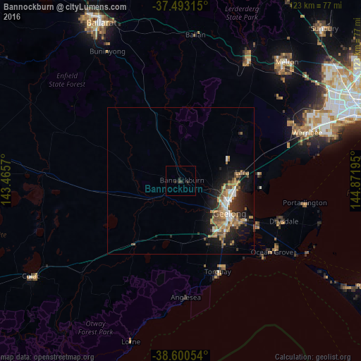
Analysis of Bannockburn night lights 2016
Square area 10x10 km:
 0%
0%90-99
0%80-89
0%70-79
0%60-69
0%50-59
0%40-49
0.49%30-39
1.62%20-29
1.14%10-19
0%0-9
96.75%Square area 50x50 km:
0.7%90-99
0.69%80-89
0.3%70-79
1.41%60-69
0.99%50-59
0.89%40-49
1.01%30-39
0.74%20-29
1.64%10-19
4.64%0-9
86.99%Clear (daylight) street map image can be seen on geolist.org.
Map coordinates:
37° 29' 35.3" South, 143° 27' 56.5" East
38° 2' 56.2" South, 144° 10' 7.8" East
38° 36' 1.9" South, 144° 52' 19" East
Some cities around Bannockburn sort by population:
• Geelong
20 km =12.4 mi,  123°
123°
• Highton
18.4 km =11.4 mi,  137°
137°
• Corio
19.2 km =11.9 mi,  101°
101°
• Newtown
18.7 km =11.6 mi,  128°
128°
• Norlane
17.2 km =10.7 mi,  109°
109°
• Geelong West
18.6 km =11.6 mi, 122°
• Hamlyn Heights
16.1 km =10 mi, 119°
• Geelong city centre
20.3 km =12.6 mi, 123°
2176938 (p: 5,203)
Sources (retrieved 2019-11-25):
» Earth at Night: Flat Maps 2012, 2016