Wolfurt night lights from space
Night Light of Wolfurt (Vorarlberg) from space (Austria) Src. Average luminocity for 10x10km area is 27.2116% and for 50x50km: 6.944%.
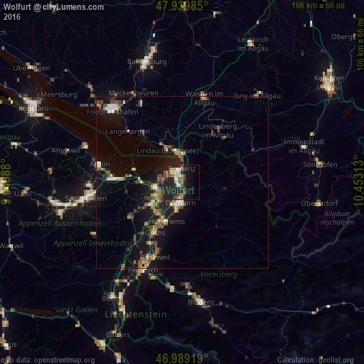
Analysis of Wolfurt night lights 2016
Square area 10x10 km:
 1.99%
1.99%90-99
5.26%80-89
1.99%70-79
2.56%60-69
4.12%50-59
5.68%40-49
2.98%30-39
3.27%20-29
18.18%10-19
24.01%0-9
29.97%Square area 50x50 km:
0.39%90-99
0.79%80-89
0.54%70-79
0.73%60-69
1.15%50-59
1.31%40-49
1.59%30-39
1.07%20-29
1.94%10-19
7.08%0-9
83.4%Clear (daylight) street map image can be seen on geolist.org.
Map coordinates:
47° 56' 23.5" North, 9° 2' 48.8" East
47° 28' 0" North, 9° 45' 0" East
46° 59' 21.1" North, 10° 27' 11.3" East
Some cities around Wolfurt sort by population:
• Dornbirn
5.9 km =3.7 mi,  185°
185°
• Bregenz
4.1 km =2.5 mi,  356°
356°
• Lustenau
8.2 km =5.1 mi,  236°
236°
• Hard
5.4 km =3.4 mi,  289°
289°
• Lauterach
1.8 km =1.1 mi,  303°
303°
• Höchst
8.3 km =5.2 mi,  264°
264°
• Lochau
7.4 km =4.6 mi,  0°
0°
• Sankt Margrethen, CH
8.6 km =5.3 mi, 259°
2760894 (p: 8,446)
Sources (retrieved 2019-11-25):
» Earth at Night: Flat Maps 2012, 2016