Sankt Veit an der Glan night lights from space
Night Light of Sankt Veit an der Glan (Carinthia) from space (Austria) Src. Average luminocity for 10x10km area is 7.6949% and for 50x50km: 2.4913%.
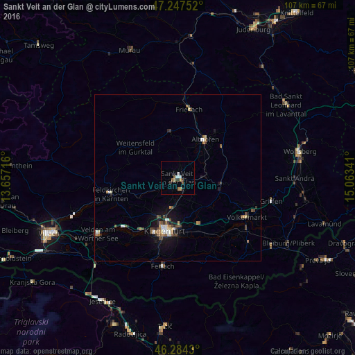
Analysis of Sankt Veit an der Glan night lights 2016
Square area 10x10 km:
 1.34%
1.34%90-99
1.04%80-89
1.19%70-79
0.89%60-69
0.45%50-59
1.19%40-49
0.45%30-39
2.38%20-29
0%10-19
0.6%0-9
90.48%Square area 50x50 km:
0.3%90-99
0.34%80-89
0.26%70-79
0.22%60-69
0.3%50-59
0.48%40-49
0.53%30-39
0.32%20-29
0.33%10-19
1.53%0-9
95.39%Clear (daylight) street map image can be seen on geolist.org.
Map coordinates:
47° 14' 51.1" North, 13° 39' 25.8" East
46° 46' 5" North, 14° 21' 37" East
46° 17' 3.5" North, 15° 3' 48.3" East
Some cities around Sankt Veit an der Glan sort by population:
• Klagenfurt am Wörthersee
16.5 km =10.3 mi,  194°
194°
• Villach
42.3 km =26.3 mi,  245°
245°
• Annabichl
13.5 km =8.4 mi, 194°
• Viktring
20.8 km =12.9 mi,  199°
199°
• Villacher Vorstadt
17 km =10.6 mi, 198°
• Finkenstein am Faaker See
38.7 km =24 mi,  237°
237°
• Wölfnitz
13.7 km =8.5 mi,  214°
214°
• Lind
42.3 km =26.3 mi, 247°
2766359 (p: 10,841)
Sources (retrieved 2019-11-25):
» Earth at Night: Flat Maps 2012, 2016