Finkenstein am Faaker See night lights from space
Night Light of Finkenstein am Faaker See (Carinthia) from space (Austria) Src. Average luminocity for 10x10km area is 3.598% and for 50x50km: 2.4395%.
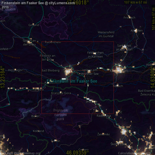
Analysis of Finkenstein am Faaker See night lights 2016
Square area 10x10 km:
 0.28%
0.28%90-99
0.28%80-89
0.57%70-79
0%60-69
0%50-59
0%40-49
1.7%30-39
0.85%20-29
0.28%10-19
3.13%0-9
92.9%Square area 50x50 km:
0.22%90-99
0.48%80-89
0.29%70-79
0.32%60-69
0.12%50-59
0.23%40-49
0.49%30-39
0.36%20-29
0.3%10-19
1.25%0-9
95.94%Clear (daylight) street map image can be seen on geolist.org.
Map coordinates:
47° 3' 36.6" North, 13° 13' 54.6" East
46° 34' 44.5" North, 13° 56' 5.9" East
46° 5' 36.9" North, 14° 38' 17.1" East
Some cities around Finkenstein am Faaker See sort by population:
• Villach
7 km =4.3 mi,  299°
299°
• Jesenice, SI
19.4 km =12.1 mi,  148°
148°
• Villach-Innere Stadt
7.7 km =4.8 mi, 298°
• Auen
7.3 km =4.5 mi,  288°
288°
• Völkendorf
8.5 km =5.3 mi, 292°
• Lind
8.3 km =5.2 mi,  305°
305°
• Kranjska Gora, SI
18.1 km =11.2 mi,  221°
221°
• Zgornje Gorje, SI
24.4 km =15.2 mi,  155°
155°
3218464 (p: 8,406)
Sources (retrieved 2019-11-25):
» Earth at Night: Flat Maps 2012, 2016