Villacher Vorstadt night lights from space
Night Light of Villacher Vorstadt (Carinthia) from space (Austria) Src. Average luminocity for 10x10km area is 27.0554% and for 50x50km: 2.633%.
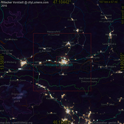
Analysis of Villacher Vorstadt night lights 2016
Square area 10x10 km:
 3.98%
3.98%90-99
4.83%80-89
2.56%70-79
0.71%60-69
4.4%50-59
5.68%40-49
4.97%30-39
3.41%20-29
3.98%10-19
28.98%0-9
36.51%Square area 50x50 km:
0.32%90-99
0.42%80-89
0.27%70-79
0.22%60-69
0.23%50-59
0.5%40-49
0.49%30-39
0.34%20-29
0.37%10-19
1.5%0-9
95.34%Clear (daylight) street map image can be seen on geolist.org.
Map coordinates:
47° 6' 15.9" North, 13° 35' 8.9" East
46° 37' 25.2" North, 14° 17' 20.1" East
46° 8' 19.1" North, 14° 59' 31.4" East
Some cities around Villacher Vorstadt sort by population:
• Klagenfurt am Wörthersee
1.3 km =0.8 mi,  84°
84°
• Sankt Peter
4 km =2.5 mi, 80°
• Sankt Martin
0.9 km =0.6 mi,  208°
208°
• Annabichl
3.6 km =2.2 mi,  35°
35°
• Sankt Veit an der Glan
17 km =10.6 mi,  18°
18°
• Viktring
3.8 km =2.4 mi,  203°
203°
• Sankt Ruprecht
3.4 km =2.1 mi,  141°
141°
• Wölfnitz
5.3 km =3.3 mi,  333°
333°
11704364 (p: 8,421)
Sources (retrieved 2019-11-25):
» Earth at Night: Flat Maps 2012, 2016