Waging am See night lights from space
Night Light of Waging am See (Bavaria) from space (Germany) Src. Average luminocity for 10x10km area is 0.5241% and for 50x50km: 4.483%.
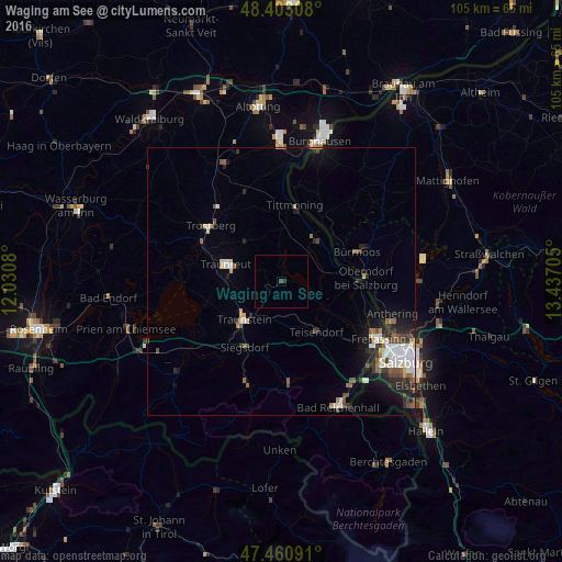
Analysis of Waging am See night lights 2016
Square area 10x10 km:
 0%
0%90-99
0%80-89
0%70-79
0%60-69
0%50-59
0%40-49
0.57%30-39
0.14%20-29
0.43%10-19
0%0-9
98.86%Square area 50x50 km:
0.85%90-99
0.81%80-89
0.39%70-79
0.27%60-69
0.45%50-59
0.63%40-49
0.7%30-39
0.55%20-29
1.35%10-19
2.23%0-9
91.75%Clear (daylight) street map image can be seen on geolist.org.
Map coordinates:
48° 24' 11.1" North, 12° 1' 50.9" East
47° 56' 2.9" North, 12° 44' 2.1" East
47° 27' 39.3" North, 13° 26' 13.4" East
Some cities around Waging am See sort by population:
• Traunreut
11 km =6.8 mi,  286°
286°
• Traunstein
10 km =6.2 mi,  222°
222°
• Trostberg an der Alz
16.7 km =10.4 mi,  308°
308°
• Teisendorf
11.4 km =7.1 mi,  146°
146°
• Siegsdorf
14.1 km =8.8 mi,  208°
208°
• Laufen
14.5 km =9 mi,  89°
89°
• Tittmoning
14.4 km =8.9 mi,  10°
10°
• Oberndorf bei Salzburg, AT
15 km =9.3 mi,  83°
83°
2815484 (p: 6,291)
Sources (retrieved 2019-11-25):
» Earth at Night: Flat Maps 2012, 2016