Villa Dolores night lights from space
Night Light of Villa Dolores (Cordoba) from space (Argentina) Src. Average luminocity for 10x10km area is 39.8619% and for 50x50km: 3.9674%.
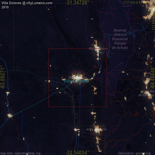

Analysis of Villa Dolores night lights 2016
Square area 10x10 km:
 4.37%
4.37%90-99
6.82%80-89
6.47%70-79
4.9%60-69
7.17%50-59
3.15%40-49
4.37%30-39
9.97%20-29
9.27%10-19
37.59%0-9
5.94%Square area 50x50 km:
0.26%90-99
0.38%80-89
0.73%70-79
0.51%60-69
0.55%50-59
0.39%40-49
0.49%30-39
1%20-29
0.84%10-19
3.54%0-9
91.3%Clear (daylight) street map image can be seen on geolist.org.
Map coordinates:
31° 20' 50.2" South, 65° 53' 33.8" West
31° 56' 45.1" South, 65° 11' 22.5" West
32° 32' 25.9" South, 64° 29' 11.3" West
Some cities around Villa Dolores sort by population:
• Alta Gracia
79 km =49.1 mi,  65°
65°
• Embalse
77.2 km =48 mi,  109°
109°
• Merlo
47.1 km =29.3 mi,  159°
159°
• Almafuerte
92.2 km =57.3 mi, 107°
• Santa Rosa de Calamuchita
63.1 km =39.2 mi,  102°
102°
• Mina Clavero
30.4 km =18.9 mi,  34°
34°
• Despeñaderos
86.2 km =53.6 mi,  80°
80°
• Tilisarao
88 km =54.7 mi,  186°
186°
3832756 (p: 28,009)
Sources (retrieved 2019-11-25):
» Earth at Night: Flat Maps 2012, 2016