Mina Clavero night lights from space
Night Light of Mina Clavero (Cordoba) from space (Argentina) Src. Average luminocity for 10x10km area is 28.1593% and for 50x50km: 2.7537%.
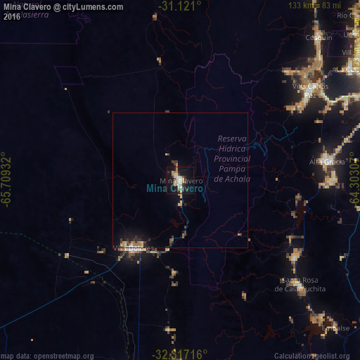
Analysis of Mina Clavero night lights 2016
Square area 10x10 km:
 3.66%
3.66%90-99
3.85%80-89
6.78%70-79
2.2%60-69
4.4%50-59
1.1%40-49
1.83%30-39
4.95%20-29
3.11%10-19
36.81%0-9
31.32%Square area 50x50 km:
0.2%90-99
0.25%80-89
0.61%70-79
0.29%60-69
0.42%50-59
0.19%40-49
0.17%30-39
0.69%20-29
0.42%10-19
2.89%0-9
93.87%Clear (daylight) street map image can be seen on geolist.org.
Map coordinates:
31° 7' 15.6" South, 65° 42' 33.6" West
31° 43' 15.6" South, 65° 0' 22.3" West
32° 19' 1.8" South, 64° 18' 11.1" West
Some cities around Mina Clavero sort by population:
• Villa Carlos Paz
58.4 km =36.3 mi,  55°
55°
• Alta Gracia
55.2 km =34.3 mi,  82°
82°
• Villa Dolores
30.4 km =18.9 mi,  214°
214°
• Merlo
69.1 km =42.9 mi,  180°
180°
• Santa Rosa de Calamuchita
58.9 km =36.6 mi,  131°
131°
• Malagueño
67.6 km =42 mi,  65°
65°
• Villa General Belgrano
51.2 km =31.8 mi,  123°
123°
• Despeñaderos
68.5 km =42.6 mi,  98°
98°
3844229 (p: 6,855)
Sources (retrieved 2019-11-25):
» Earth at Night: Flat Maps 2012, 2016