Villa de Soto night lights from space
Night Light of Villa de Soto (Cordoba) from space (Argentina) Src. Average luminocity for 10x10km area is 9.9458% and for 50x50km: 1.7621%.
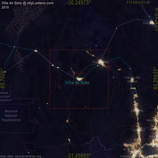
Analysis of Villa de Soto night lights 2016
Square area 10x10 km:
 0.35%
0.35%90-99
1.75%80-89
2.1%70-79
1.4%60-69
1.4%50-59
0.87%40-49
0.87%30-39
3.5%20-29
0.7%10-19
0%0-9
87.06%Square area 50x50 km:
0.13%90-99
0.17%80-89
0.26%70-79
0.29%60-69
0.26%50-59
0.14%40-49
0.22%30-39
0.62%20-29
0.21%10-19
0.77%0-9
96.94%Clear (daylight) street map image can be seen on geolist.org.
Map coordinates:
30° 14' 59" South, 65° 42' 9.4" West
30° 51' 18.8" South, 64° 59' 58.1" West
31° 27' 24.9" South, 64° 17' 46.9" West
Some cities around Villa de Soto sort by population:
• Cruz del Eje
23.5 km =14.6 mi,  52°
52°
• Cosquín
66.8 km =41.5 mi,  130°
130°
• Río Ceballos
73.1 km =45.4 mi,  118°
118°
• La Falda
55.1 km =34.2 mi, 118°
• Capilla del Monte
45.3 km =28.1 mi,  90°
90°
• La Cumbre
50.5 km =31.4 mi,  106°
106°
• Huerta Grande
54.3 km =33.7 mi, 116°
• Valle Hermoso
57.4 km =35.7 mi, 120°
3832759 (p: 7,303)
Sources (retrieved 2019-11-25):
» Earth at Night: Flat Maps 2012, 2016