Huerta Grande night lights from space
Night Light of Huerta Grande (Cordoba) from space (Argentina) Src. Average luminocity for 10x10km area is 29.6044% and for 50x50km: 7.9659%.
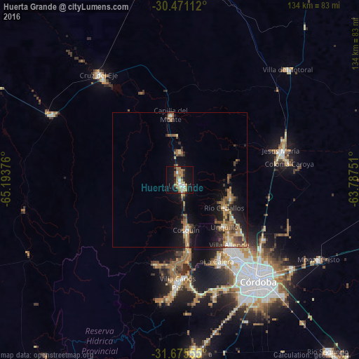
Analysis of Huerta Grande night lights 2016
Square area 10x10 km:
 4.21%
4.21%90-99
2.75%80-89
2.93%70-79
3.48%60-69
10.81%50-59
3.66%40-49
1.47%30-39
3.11%20-29
2.75%10-19
34.25%0-9
30.59%Square area 50x50 km:
0.44%90-99
0.59%80-89
0.98%70-79
1.13%60-69
2.22%50-59
1.2%40-49
1.32%30-39
1.52%20-29
1.58%10-19
6.45%0-9
82.58%Clear (daylight) street map image can be seen on geolist.org.
Map coordinates:
30° 28' 16" South, 65° 11' 37.5" West
31° 4' 30.9" South, 64° 29' 26.3" West
31° 40' 32" South, 63° 47' 15" West
Some cities around Huerta Grande sort by population:
• Cosquín
19 km =11.8 mi,  172°
172°
• Río Ceballos
18.9 km =11.7 mi,  121°
121°
• Unquillo
24 km =14.9 mi,  136°
136°
• La Falda
1.5 km =0.9 mi,  177°
177°
• Capilla del Monte
24.1 km =15 mi,  352°
352°
• La Cumbre
10.4 km =6.5 mi,  359°
359°
• Salsipuedes
19.8 km =12.3 mi,  110°
110°
• Valle Hermoso
4.8 km =3 mi, 168°
3854008 (p: 5,630)
Sources (retrieved 2019-11-25):
» Earth at Night: Flat Maps 2012, 2016