Valle Hermoso night lights from space
Night Light of Valle Hermoso (Cordoba) from space (Argentina) Src. Average luminocity for 10x10km area is 24.652% and for 50x50km: 10.6228%.
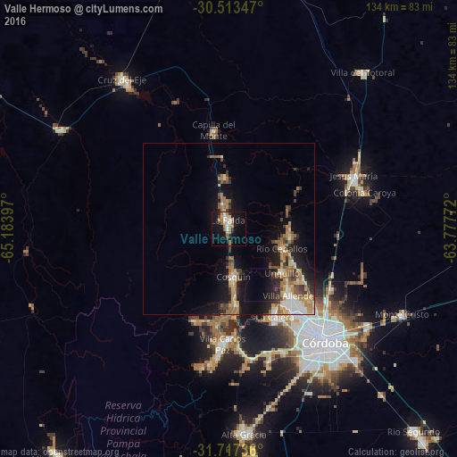
Analysis of Valle Hermoso night lights 2016
Square area 10x10 km:
 3.48%
3.48%90-99
3.11%80-89
2.2%70-79
3.85%60-69
7.14%50-59
1.83%40-49
0.37%30-39
2.2%20-29
2.56%10-19
29.3%0-9
43.96%Square area 50x50 km:
1%90-99
1.16%80-89
1.33%70-79
1.65%60-69
2.53%50-59
1.39%40-49
1.4%30-39
1.76%20-29
2.12%10-19
8.03%0-9
77.63%Clear (daylight) street map image can be seen on geolist.org.
Map coordinates:
30° 30' 48.5" South, 65° 11' 2.3" West
31° 7' 2.4" South, 64° 28' 51" West
31° 43' 2.5" South, 63° 46' 39.8" West
Some cities around Valle Hermoso sort by population:
• Villa Allende
26.4 km =16.4 mi,  138°
138°
• Cosquín
14.3 km =8.9 mi,  174°
174°
• Río Ceballos
16 km =9.9 mi,  109°
109°
• Unquillo
20.1 km =12.5 mi,  128°
128°
• La Falda
3.3 km =2.1 mi,  345°
345°
• La Cumbre
15.1 km =9.4 mi,  356°
356°
• Salsipuedes
17.7 km =11 mi,  97°
97°
• Huerta Grande
4.8 km =3 mi, 348°
3833211 (p: 5,486)
Sources (retrieved 2019-11-25):
» Earth at Night: Flat Maps 2012, 2016