Termas de Río Hondo night lights from space
Night Light of Termas de Río Hondo (Santiago del Estero) from space (Argentina) Src. Average luminocity for 10x10km area is 39.004% and for 50x50km: 2.3233%.
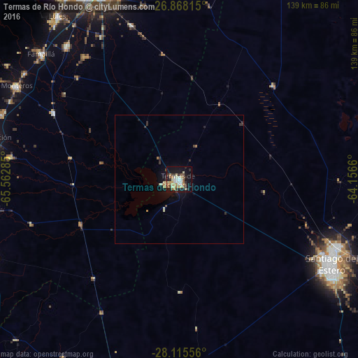

Analysis of Termas de Río Hondo night lights 2016
Square area 10x10 km:
 4.17%
4.17%90-99
6.75%80-89
8.33%70-79
5.56%60-69
6.55%50-59
4.17%40-49
2.78%30-39
7.14%20-29
4.76%10-19
35.32%0-9
14.48%Square area 50x50 km:
0.16%90-99
0.34%80-89
0.43%70-79
0.28%60-69
0.36%50-59
0.2%40-49
0.16%30-39
0.51%20-29
0.34%10-19
2.37%0-9
94.85%Clear (daylight) street map image can be seen on geolist.org.
Map coordinates:
26° 52' 5.3" South, 65° 33' 46.3" West
27° 29' 37" South, 64° 51' 35" West
28° 6' 56" South, 64° 9' 23.8" West
Some cities around Termas de Río Hondo sort by population:
• Santiago del Estero
67.8 km =42.1 mi,  119°
119°
• Aguilares
74.7 km =46.4 mi,  275°
275°
• Famaillá
72.6 km =45.1 mi,  312°
312°
• Monteros
72.8 km =45.2 mi,  299°
299°
• Bella Vista
67.2 km =41.8 mi,  319°
319°
• Clodomira
72.4 km =45 mi,  97°
97°
• Simoca
55.4 km =34.4 mi, 297°
• Graneros
59.6 km =37 mi,  253°
253°
3834502 (p: 27,838)
Sources (retrieved 2019-11-25):
» Earth at Night: Flat Maps 2012, 2016