Capioví night lights from space
Night Light of Capioví (Misiones) from space (Argentina) Src. Average luminocity for 10x10km area is 7.1885% and for 50x50km: 3.3998%.
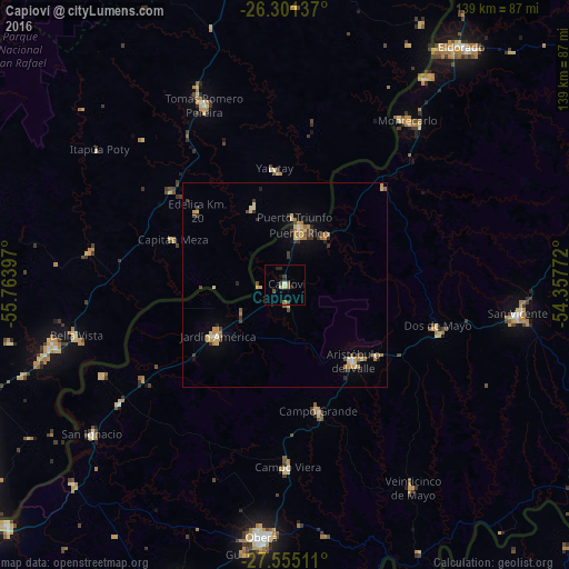
Analysis of Capioví night lights 2016
Square area 10x10 km:
 0%
0%90-99
0.79%80-89
0.79%70-79
0.79%60-69
0.99%50-59
1.79%40-49
1.39%30-39
1.39%20-29
3.17%10-19
0.79%0-9
88.1%Square area 50x50 km:
0.1%90-99
0.18%80-89
0.84%70-79
0.57%60-69
0.67%50-59
0.25%40-49
0.42%30-39
0.77%20-29
0.5%10-19
0.76%0-9
94.94%Clear (daylight) street map image can be seen on geolist.org.
Map coordinates:
26° 18' 4.9" South, 55° 45' 50.3" West
26° 55' 47.9" South, 55° 3' 39" West
27° 33' 18.4" South, 54° 21' 27.8" West
Some cities around Capioví sort by population:
• Jardín América
20.7 km =12.9 mi,  232°
232°
• Aristóbulo del Valle
24.6 km =15.3 mi,  138°
138°
• Puerto Rico
15.3 km =9.5 mi,  13°
13°
• Dos de Mayo
38.5 km =23.9 mi,  105°
105°
• Campo Grande
31.9 km =19.8 mi,  165°
165°
• Garuhapé
16.2 km =10.1 mi,  39°
39°
• Santo Pipó
41.7 km =25.9 mi,  235°
235°
• El Alcázar
34.2 km =21.3 mi,  45°
45°
3435701 (p: 5,860)
Sources (retrieved 2019-11-25):
» Earth at Night: Flat Maps 2012, 2016