San Clemente del Tuyú night lights from space
Night Light of San Clemente del Tuyú (Buenos Aires) from space (Argentina) Src. Average luminocity for 10x10km area is 19.3007% and for 50x50km: 2.8238%.
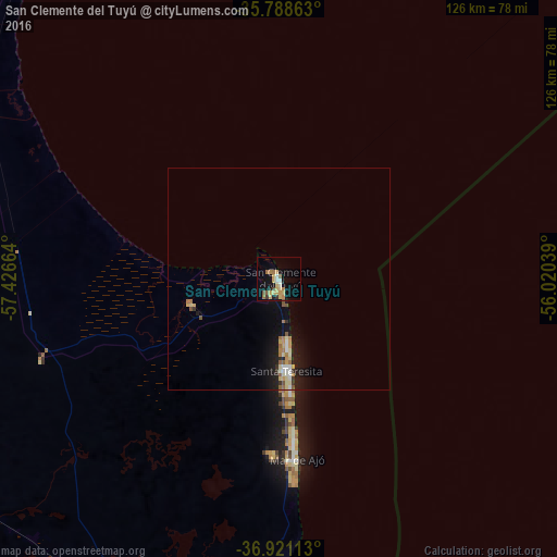
Analysis of San Clemente del Tuyú night lights 2016
Square area 10x10 km:
 0.52%
0.52%90-99
2.27%80-89
5.42%70-79
4.2%60-69
3.67%50-59
1.75%40-49
1.4%30-39
1.4%20-29
0.87%10-19
11.36%0-9
67.13%Square area 50x50 km:
0.19%90-99
0.35%80-89
0.59%70-79
0.44%60-69
0.45%50-59
0.38%40-49
0.12%30-39
0.23%20-29
0.33%10-19
2.62%0-9
94.3%Clear (daylight) street map image can be seen on geolist.org.
Map coordinates:
35° 47' 19.1" South, 57° 25' 35.9" West
36° 21' 25" South, 56° 43' 24.6" West
36° 55' 16.1" South, 56° 1' 13.4" West
Some cities around San Clemente del Tuyú sort by population:
• Montevideo, UY
168.7 km =104.8 mi,  16°
16°
• Las Piedras, UY
186.5 km =115.9 mi,  14°
14°
• Dolores
85.7 km =53.3 mi,  273°
273°
• Villa Gesell
103.3 km =64.2 mi,  192°
192°
• La Paz, UY
183.1 km =113.8 mi, 14°
• Delta del Tigre, UY
180 km =111.8 mi, 10°
• Paso de Carrasco, UY
177.1 km =110 mi, 20°
• Colonia Nicolich, UY
182.7 km =113.5 mi, 20°
3429160 (p: 11,174)
Sources (retrieved 2019-11-25):
» Earth at Night: Flat Maps 2012, 2016