Recreo night lights from space
Night Light of Recreo (Catamarca) from space (Argentina) Src. Average luminocity for 10x10km area is 12.3201% and for 50x50km: 0.5941%.
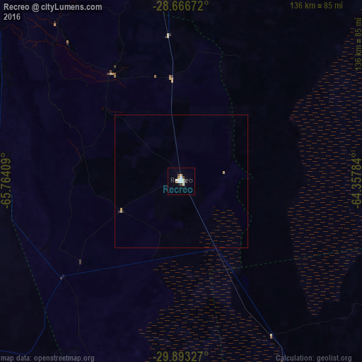
Analysis of Recreo night lights 2016
Square area 10x10 km:
 1.7%
1.7%90-99
3.79%80-89
1.52%70-79
1.33%60-69
0.76%50-59
0%40-49
1.52%30-39
1.52%20-29
0.76%10-19
0%0-9
87.12%Square area 50x50 km:
0.07%90-99
0.15%80-89
0.12%70-79
0.08%60-69
0.03%50-59
0%40-49
0.06%30-39
0.06%20-29
0.06%10-19
0.03%0-9
99.34%Clear (daylight) street map image can be seen on geolist.org.
Map coordinates:
28° 40' 0.2" South, 65° 45' 50.7" West
29° 16' 54.6" South, 65° 3' 39.5" West
29° 53' 35.8" South, 64° 21' 28.2" West
Some cities around Recreo sort by population:
• San Fernando del Valle de Catamarca
114.6 km =71.2 mi,  322°
322°
• Cruz del Eje
162.5 km =101 mi,  171°
171°
• Deán Funes
144 km =89.5 mi,  151°
151°
• Huillapima
108.6 km =67.5 mi,  304°
304°
• Icaño
47.9 km =29.8 mi,  327°
327°
• Los Altos
143.7 km =89.3 mi,  342°
342°
• Capayán
111.3 km =69.2 mi, 300°
• Villa Ojo de Agua
134.7 km =83.7 mi,  100°
100°
3839263 (p: 14,204)
Sources (retrieved 2019-11-25):
» Earth at Night: Flat Maps 2012, 2016