Rada Tilly night lights from space
Night Light of Rada Tilly (Chubut) from space (Argentina) Src. Average luminocity for 10x10km area is 38.2277% and for 50x50km: 5.6881%.
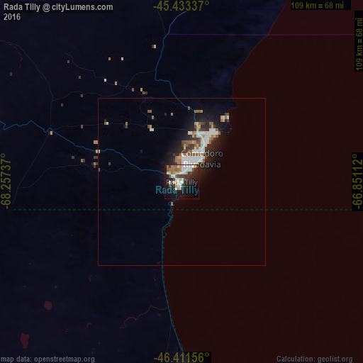
Analysis of Rada Tilly night lights 2016
Square area 10x10 km:
 6.99%
6.99%90-99
10.71%80-89
2.23%70-79
4.46%60-69
3.87%50-59
3.72%40-49
4.02%30-39
5.65%20-29
11.31%10-19
26.64%0-9
20.39%Square area 50x50 km:
0.98%90-99
1.34%80-89
0.34%70-79
0.56%60-69
0.59%50-59
0.86%40-49
0.59%30-39
0.82%20-29
1.68%10-19
3.95%0-9
88.29%Clear (daylight) street map image can be seen on geolist.org.
Map coordinates:
45° 26' 0.1" South, 68° 15' 26.5" West
45° 55' 28.6" South, 67° 33' 15.3" West
46° 24' 41.6" South, 66° 51' 4" West
Some cities around Rada Tilly sort by population:
• Comodoro Rivadavia
8.1 km =5 mi,  33°
33°
• Trelew
346.7 km =215.4 mi, 30°
• Caleta Olivia
57.3 km =35.6 mi,  177°
177°
• Pico Truncado
101.6 km =63.1 mi,  197°
197°
• Puerto Deseado
239.1 km =148.6 mi,  148°
148°
• Las Heras
126.5 km =78.6 mi,  237°
237°
• Sarmiento
123.4 km =76.7 mi,  287°
287°
• Gaimán
335.3 km =208.3 mi, 29°
3839482 (p: 6,208)
Sources (retrieved 2019-11-25):
» Earth at Night: Flat Maps 2012, 2016