General Enrique Mosconi night lights from space
Night Light of General Enrique Mosconi (Salta) from space (Argentina) Src. Average luminocity for 10x10km area is 24.1515% and for 50x50km: 2.5844%.
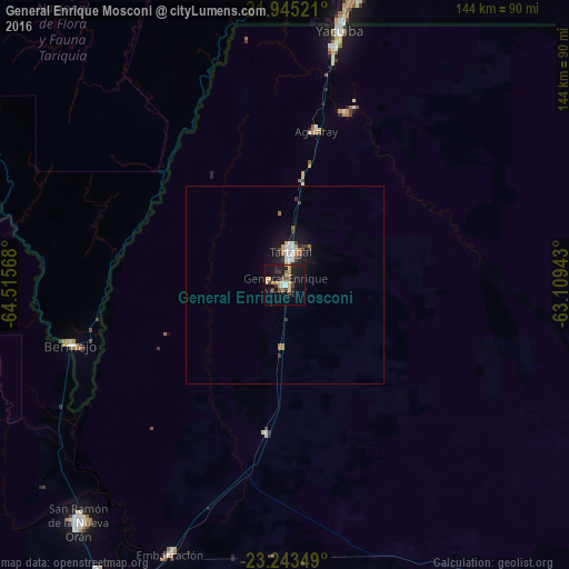
Analysis of General Enrique Mosconi night lights 2016
Square area 10x10 km:
 1.89%
1.89%90-99
1.52%80-89
4.55%70-79
4.92%60-69
2.08%50-59
2.84%40-49
3.22%30-39
4.73%20-29
4.17%10-19
30.68%0-9
39.39%Square area 50x50 km:
0.39%90-99
0.31%80-89
0.22%70-79
0.37%60-69
0.38%50-59
0.19%40-49
0.27%30-39
0.46%20-29
0.38%10-19
2.75%0-9
94.28%Clear (daylight) street map image can be seen on geolist.org.
Map coordinates:
21° 56' 42.8" South, 64° 30' 56.4" West
22° 35' 45.2" South, 63° 48' 45.2" West
23° 14' 36.6" South, 63° 6' 33.9" West
Some cities around General Enrique Mosconi sort by population:
• Tarija, BO
151.1 km =93.9 mi,  321°
321°
• Yacuiba, BO
65.9 km =40.9 mi,  12°
12°
• San Ramón de la Nueva Orán
79.8 km =49.6 mi,  221°
221°
• Tartagal
8.9 km =5.5 mi, 7°
• Bermejo, BO
55.9 km =34.7 mi,  254°
254°
• Embarcación
74.3 km =46.2 mi,  203°
203°
• Yuto
134.6 km =83.6 mi,  210°
210°
• Caimancito
150.3 km =93.4 mi, 212°
3855116 (p: 19,811)
Sources (retrieved 2019-11-25):
» Earth at Night: Flat Maps 2012, 2016