Chicoana night lights from space
Night Light of Chicoana (Salta) from space (Argentina) Src. Average luminocity for 10x10km area is 18.8977% and for 50x50km: 6.7099%.
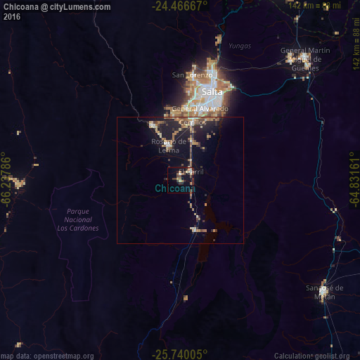
Analysis of Chicoana night lights 2016
Square area 10x10 km:
 1.14%
1.14%90-99
1.7%80-89
3.6%70-79
1.7%60-69
3.6%50-59
2.08%40-49
4.73%30-39
4.36%20-29
3.03%10-19
13.45%0-9
60.61%Square area 50x50 km:
0.3%90-99
0.57%80-89
0.91%70-79
0.86%60-69
1.44%50-59
0.76%40-49
1.2%30-39
1.25%20-29
2.22%10-19
5.79%0-9
84.68%Clear (daylight) street map image can be seen on geolist.org.
Map coordinates:
24° 28' 0" South, 66° 14' 16.3" West
25° 6' 18.1" South, 65° 32' 5" West
25° 44' 24.2" South, 64° 49' 53.8" West
Some cities around Chicoana sort by population:
• Salta
37.6 km =23.4 mi,  19°
19°
• San Salvador de Jujuy
104 km =64.6 mi,  13°
13°
• San Pedro de Jujuy
118.3 km =73.5 mi,  34°
34°
• Palpalá
99.8 km =62 mi, 19°
• Cafayate
116.4 km =72.3 mi,  202°
202°
• El Carril
5.5 km =3.4 mi,  51°
51°
• El Galpón
93.9 km =58.3 mi,  109°
109°
• Ingenio La Esperanza
120.4 km =74.8 mi,  35°
35°
3861494 (p: 8,468)
Sources (retrieved 2019-11-25):
» Earth at Night: Flat Maps 2012, 2016