Khulm night lights from space
Night Light of Khulm (Balkh) from space (Afghanistan) Src. Average luminocity for 10x10km area is 2.4451% and for 50x50km: 0.0915%.
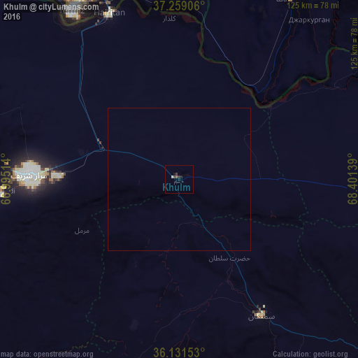
Analysis of Khulm night lights 2016
Square area 10x10 km:
 0%
0%90-99
0.73%80-89
0%70-79
0%60-69
0%50-59
0.73%40-49
0.92%30-39
1.1%20-29
0.18%10-19
1.47%0-9
94.87%Square area 50x50 km:
0%90-99
0.03%80-89
0%70-79
0%60-69
0%50-59
0.03%40-49
0.03%30-39
0.04%20-29
0.01%10-19
0.05%0-9
99.81%Clear (daylight) street map image can be seen on geolist.org.
Map coordinates:
37° 15' 32.6" North, 66° 59' 42.5" East
36° 41' 50.5" North, 67° 41' 53.7" East
36° 7' 53.5" North, 68° 24' 5" East
Some cities around Khulm sort by population:
• Mazār-e Sharīf
52.4 km =32.6 mi,  271°
271°
• Kunduz
103.3 km =64.2 mi,  88°
88°
• Tirmiz, UZ
69.4 km =43.1 mi,  327°
327°
• Balkh
71.7 km =44.6 mi,  275°
275°
• Baghlān
110.2 km =68.5 mi,  124°
124°
• Aībak
55.8 km =34.7 mi,  149°
149°
• Shahritus, TJ
74 km =46 mi,  31°
31°
• Qarchī Gak
89.4 km =55.6 mi,  295°
295°
1136575 (p: 64,933)
Sources (retrieved 2019-11-25):
» NASA, Earths city lights 1995
» NASA city lights 2003
» Earth at Night: Flat Maps 2012, 2016