Vĩnh Yên night lights from space
Night Light of Vĩnh Yên (Vĩnh Phúc) from space (Vietnam) Src. Average luminocity for 10x10km area is 49.0852% and for 50x50km: 19.2925%.
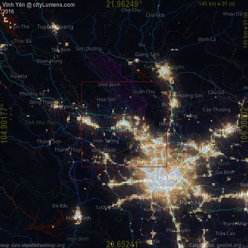
Analysis of Vĩnh Yên night lights 2016
Square area 10x10 km:
 5.68%
5.68%90-99
8.52%80-89
7.01%70-79
5.87%60-69
9.85%50-59
6.25%40-49
10.98%30-39
11.36%20-29
14.58%10-19
19.32%0-9
0.57%Square area 50x50 km:
1.24%90-99
1.64%80-89
3.03%70-79
3.78%60-69
5.42%50-59
2.89%40-49
3.05%30-39
3.23%20-29
4.25%10-19
10.33%0-9
61.14%Clear (daylight) street map image can be seen on geolist.org.
Map coordinates:
21° 57' 45" North, 104° 54' 6.4" East
21° 18' 32.1" North, 105° 36' 17.6" East
20° 39' 8.7" North, 106° 18' 28.9" East
Some cities around Vĩnh Yên sort by population:
• Hanoi
40 km =24.9 mi,  142°
142°
• Thái Nguyên
40.5 km =25.2 mi,  38°
38°
• Việt Trì
21.1 km =13.1 mi,  274°
274°
• Cung Kiệm
59.2 km =36.8 mi,  103°
103°
• Bắc Giang
61.2 km =38 mi,  93°
93°
• Hà Đông
41.6 km =25.8 mi,  154°
154°
• Bắc Ninh
50.7 km =31.5 mi,  105°
105°
• Sơn Tây
21.3 km =13.2 mi,  208°
208°
1562548 (p: 17,876)
Sources (retrieved 2019-11-25):
» Earth at Night: Flat Maps 2012, 2016