Cát Bà night lights from space
Night Light of Cát Bà (Haiphong) from space (Vietnam) Src. Average luminocity for 10x10km area is 4.4318% and for 50x50km: 5.3487%.
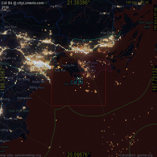

Analysis of Cát Bà night lights 2016
Square area 10x10 km:
 0%
0%90-99
0%80-89
0%70-79
0%60-69
2.27%50-59
1.52%40-49
0%30-39
1.14%20-29
1.89%10-19
2.27%0-9
90.91%Square area 50x50 km:
0.15%90-99
0.14%80-89
0.6%70-79
0.8%60-69
0.69%50-59
0.62%40-49
1.11%30-39
1.48%20-29
1.98%10-19
5.83%0-9
86.59%Clear (daylight) street map image can be seen on geolist.org.
Map coordinates:
21° 23' 2.3" North, 106° 20' 42.3" East
20° 43' 40" North, 107° 2' 53.5" East
20° 4' 7.5" North, 107° 45' 4.8" East
Some cities around Cát Bà sort by population:
• Haiphong
40.9 km =25.4 mi,  291°
291°
• Nam Định
96.4 km =59.9 mi,  250°
250°
• Hạ Long
24.9 km =15.5 mi,  6°
6°
• Cẩm Phả Mines
41.4 km =25.7 mi,  39°
39°
• Thành Phố Uông Bí
44.7 km =27.8 mi,  319°
319°
• Hải Dương
78 km =48.5 mi, 287°
• Thái Bình
79.9 km =49.6 mi, 247°
• Hưng Yên
104.1 km =64.7 mi,  265°
265°
1586052 (p: 30,000)
Sources (retrieved 2019-11-25):
» Earth at Night: Flat Maps 2012, 2016