Woodinville night lights from space
Night Light of Woodinville (Washington) from space (United States) Src. Average luminocity for 10x10km area is 65.2887% and for 50x50km: 36.2987%.
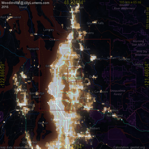
Analysis of Woodinville night lights 2016
Square area 10x10 km:
 11.61%
90-99
14.58%80-89
5.95%70-79
12.35%60-69
18.9%50-59
6.85%40-49
10.57%30-39
6.4%20-29
8.18%10-19
4.61%0-9
0%Square area 50x50 km:
9.5%90-99
8.11%80-89
2.76%70-79
4.71%60-69
6.07%50-59
4.28%40-49
4.53%30-39
5.1%20-29
5.3%10-19
7.35%0-9
42.3%Clear (daylight) street map image can be seen on geolist.org.
Map coordinates:
48° 13' 29.4" North, 122° 51' 59.7" West
47° 45' 15.4" North, 122° 9' 48.5" West
47° 16' 45.8" North, 121° 27' 37.2" West
Some cities around Woodinville sort by population:
• Bothell
3.3 km =2.1 mi,  285°
285°
• North Creek
7.3 km =4.5 mi,  352°
352°
• Inglewood-Finn Hill
6.3 km =3.9 mi,  233°
233°
• Cottage Lake
6.5 km =4 mi,  99°
99°
• Kenmore
6 km =3.7 mi,  273°
273°
• Kingsgate
3.3 km =2.1 mi,  201°
201°
• Maltby
6.8 km =4.2 mi,  33°
33°
• Bothell East
6 km =3.7 mi,  344°
344°
5816449 (p: 11,782)
Sources (retrieved 2019-11-25):
» Earth at Night: Flat Maps 2012, 2016