Windsor Locks night lights from space
Night Light of Windsor Locks (Connecticut) from space (United States) Src. Average luminocity for 10x10km area is 59.6175% and for 50x50km: 35.5305%.
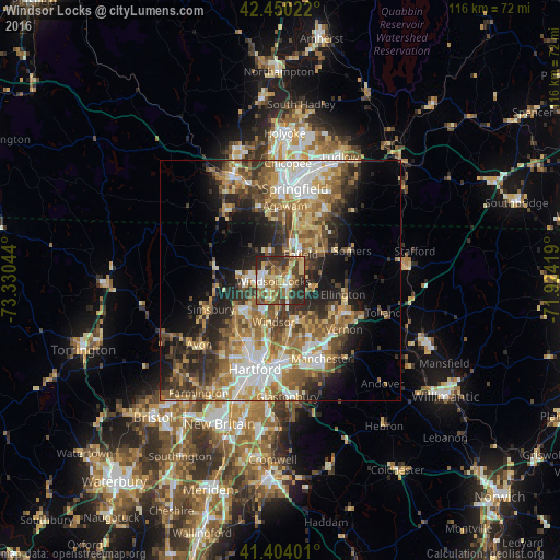
Analysis of Windsor Locks night lights 2016
Square area 10x10 km:
 6.03%
6.03%90-99
7.14%80-89
16.67%70-79
6.51%60-69
11.43%50-59
14.13%40-49
9.68%30-39
12.38%20-29
15.87%10-19
0.16%0-9
0%Square area 50x50 km:
5.13%90-99
5.54%80-89
6.13%70-79
4.76%60-69
6.67%50-59
6.45%40-49
5.2%30-39
5.97%20-29
8.15%10-19
9.83%0-9
36.17%Clear (daylight) street map image can be seen on geolist.org.
Map coordinates:
42° 27' 0.8" North, 73° 19' 49.6" West
41° 55' 45.3" North, 72° 37' 38.3" West
41° 24' 14.4" North, 71° 55' 27.1" West
Some cities around Windsor Locks sort by population:
• Enfield
6 km =3.7 mi,  29°
29°
• Agawam
15.6 km =9.7 mi,  3°
3°
• South Windsor
11.7 km =7.3 mi,  177°
177°
• Longmeadow
13.9 km =8.6 mi,  15°
15°
• Ellington
13.3 km =8.3 mi,  102°
102°
• Thompsonville
7.9 km =4.9 mi, 17°
• Southwood Acres
5.9 km =3.7 mi,  51°
51°
• Sherwood Manor
10.7 km =6.6 mi, 29°
4845926 (p: 12,498)
Sources (retrieved 2019-11-25):
» Earth at Night: Flat Maps 2012, 2016