Sherwood Manor night lights from space
Night Light of Sherwood Manor (Connecticut) from space (United States) Src. Average luminocity for 10x10km area is 62.0651% and for 50x50km: 33.2802%.
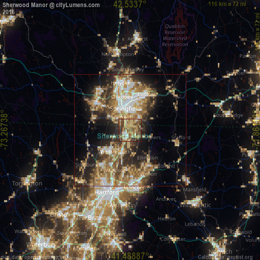
Analysis of Sherwood Manor night lights 2016
Square area 10x10 km:
 3.49%
3.49%90-99
8.1%80-89
17.62%70-79
10.63%60-69
11.43%50-59
17.46%40-49
13.65%30-39
11.59%20-29
4.76%10-19
1.27%0-9
0%Square area 50x50 km:
4.17%90-99
5.09%80-89
5.89%70-79
4.76%60-69
6.26%50-59
5.65%40-49
4.85%30-39
5.55%20-29
8.09%10-19
10.54%0-9
39.15%Clear (daylight) street map image can be seen on geolist.org.
Map coordinates:
42° 32' 1.3" North, 73° 16' 2.6" West
42° 0' 48.3" North, 72° 33' 51.3" West
41° 29' 19.9" North, 71° 51' 40.1" West
Some cities around Sherwood Manor sort by population:
• Springfield
10 km =6.2 mi,  347°
347°
• Enfield
4.7 km =2.9 mi,  208°
208°
• Agawam
7.5 km =4.7 mi,  326°
326°
• Longmeadow
4.4 km =2.7 mi,  339°
339°
• East Longmeadow
7.1 km =4.4 mi,  36°
36°
• Windsor Locks
10.7 km =6.6 mi, 209°
• Thompsonville
3.4 km =2.1 mi,  237°
237°
• Southwood Acres
5.7 km =3.5 mi,  186°
186°
4842958 (p: 5,410)
Sources (retrieved 2019-11-25):
» Earth at Night: Flat Maps 2012, 2016