Ellington night lights from space
Night Light of Ellington (Connecticut) from space (United States) Src. Average luminocity for 10x10km area is 27.5635% and for 50x50km: 32.8313%.
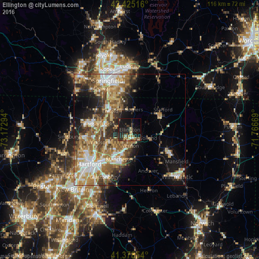
Analysis of Ellington night lights 2016
Square area 10x10 km:
 0.95%
0.95%90-99
2.06%80-89
5.71%70-79
2.7%60-69
3.49%50-59
5.24%40-49
3.81%30-39
5.08%20-29
12.54%10-19
36.98%0-9
21.43%Square area 50x50 km:
4.93%90-99
5.36%80-89
5.64%70-79
4.69%60-69
6.52%50-59
5.5%40-49
4.24%30-39
4.53%20-29
6.44%10-19
9.87%0-9
42.27%Clear (daylight) street map image can be seen on geolist.org.
Map coordinates:
42° 25' 30.6" North, 73° 10' 22.6" West
41° 54' 14.4" North, 72° 28' 11.3" West
41° 22' 42.7" North, 71° 46' 0.1" West
Some cities around Ellington sort by population:
• Enfield
12.9 km =8 mi,  308°
308°
• Manchester
14.9 km =9.3 mi,  196°
196°
• Tolland
9.1 km =5.7 mi,  113°
113°
• Windsor Locks
13.3 km =8.3 mi,  282°
282°
• Thompsonville
14.9 km =9.3 mi, 314°
• Southwood Acres
10.6 km =6.6 mi, 307°
• Rockville
4.5 km =2.8 mi,  157°
157°
• Sherwood Manor
14.5 km =9 mi,  327°
327°
4833883 (p: 14,693)
Sources (retrieved 2019-11-25):
» Earth at Night: Flat Maps 2012, 2016