Shorewood night lights from space
Night Light of Shorewood (Illinois) from space (United States) Src. Average luminocity for 10x10km area is 80.2177% and for 50x50km: 46.2917%.
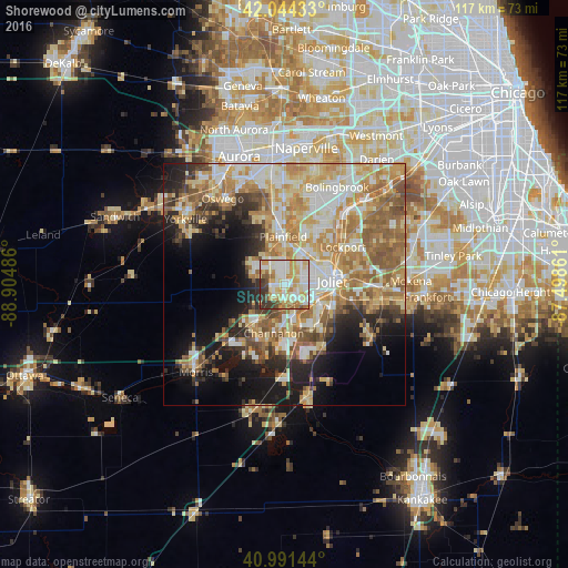
Analysis of Shorewood night lights 2016
Square area 10x10 km:
 18.54%
90-99
24.32%80-89
18.88%70-79
14.97%60-69
6.8%50-59
3.57%40-49
3.57%30-39
8.33%20-29
1.02%10-19
0%0-9
0%Square area 50x50 km:
7.27%90-99
9%80-89
8.75%70-79
8.92%60-69
8.68%50-59
7.14%40-49
3.95%30-39
3.79%20-29
6.21%10-19
11.44%0-9
24.85%Clear (daylight) street map image can be seen on geolist.org.
Map coordinates:
42° 2' 39.6" North, 88° 54' 17.5" West
41° 31' 12.1" North, 88° 12' 6.2" West
40° 59' 29.2" North, 87° 29' 55" West
Some cities around Shorewood sort by population:
• Joliet
9.9 km =6.2 mi,  86°
86°
• Plainfield
11.9 km =7.4 mi,  359°
359°
• Romeoville
17 km =10.6 mi,  33°
33°
• New Lenox
19.7 km =12.2 mi, 92°
• Lockport
14.2 km =8.8 mi,  57°
57°
• Crest Hill
9.4 km =5.8 mi,  65°
65°
• Channahon
10.3 km =6.4 mi,  192°
192°
• Minooka
8.8 km =5.5 mi,  214°
214°
4911418 (p: 16,747)
Sources (retrieved 2019-11-25):
» Earth at Night: Flat Maps 2012, 2016