Braidwood night lights from space
Night Light of Braidwood (Illinois) from space (United States) Src. Average luminocity for 10x10km area is 25.3231% and for 50x50km: 14.5554%.
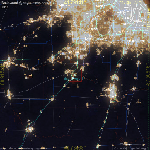
Analysis of Braidwood night lights 2016
Square area 10x10 km:
 0.32%
0.32%90-99
2.11%80-89
3.9%70-79
1.46%60-69
5.36%50-59
7.47%40-49
4.06%30-39
3.57%20-29
5.03%10-19
40.26%0-9
26.46%Square area 50x50 km:
1.15%90-99
1.4%80-89
2.37%70-79
1.65%60-69
2.4%50-59
2.94%40-49
2.93%30-39
2.57%20-29
4.37%10-19
10.75%0-9
67.46%Clear (daylight) street map image can be seen on geolist.org.
Map coordinates:
41° 47' 29.1" North, 88° 54' 55.5" West
41° 15' 54.1" North, 88° 12' 44.2" West
40° 44' 3.8" North, 87° 30' 33" West
Some cities around Braidwood sort by population:
• Bourbonnais
29.8 km =18.5 mi,  114°
114°
• Shorewood
28.4 km =17.6 mi,  1°
1°
• Morris
20.2 km =12.6 mi,  300°
300°
• Channahon
18.3 km =11.4 mi,  355°
355°
• Minooka
21.6 km =13.4 mi,  348°
348°
• Manhattan
25.8 km =16 mi,  47°
47°
• Wilmington
7.3 km =4.5 mi, 49°
• Coal City
6.6 km =4.1 mi,  292°
292°
4885444 (p: 6,172)
Sources (retrieved 2019-11-25):
» Earth at Night: Flat Maps 2012, 2016