Whitehouse night lights from space
Night Light of Whitehouse (Texas) from space (United States) Src. Average luminocity for 10x10km area is 29.5822% and for 50x50km: 15.4903%.
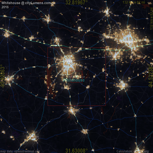
Analysis of Whitehouse night lights 2016
Square area 10x10 km:
 0%
0%90-99
0.87%80-89
5.07%70-79
3.85%60-69
4.2%50-59
5.77%40-49
7.34%30-39
12.94%20-29
14.86%10-19
21.5%0-9
23.6%Square area 50x50 km:
1.3%90-99
1.77%80-89
2.41%70-79
2.38%60-69
2.16%50-59
2.57%40-49
2.42%30-39
3.52%20-29
4.5%10-19
8.67%0-9
68.3%Clear (daylight) street map image can be seen on geolist.org.
Map coordinates:
32° 49' 10.8" North, 95° 55' 43.1" West
32° 13' 36.6" North, 95° 13' 31.8" West
31° 37' 48.3" North, 94° 31' 20.6" West
Some cities around Whitehouse sort by population:
• Tyler
15.6 km =9.7 mi,  332°
332°
• Longview
54.8 km =34.1 mi,  56°
56°
• Kilgore
37.3 km =23.2 mi, 61°
• Jacksonville
29.6 km =18.4 mi,  188°
188°
• Henderson
40.9 km =25.4 mi,  101°
101°
• Gladewater
43.5 km =27 mi,  37°
37°
• Lindale
36.5 km =22.7 mi, 331°
• Rusk
48.4 km =30.1 mi,  171°
171°
4741641 (p: 8,189)
Sources (retrieved 2019-11-25):
» Earth at Night: Flat Maps 2012, 2016